Extreme Cold Weather Warning

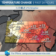
Conditions throughout the past several days have been warmer compared what we have been dealing with for the past few weeks. Even though we saw temperatures in the upper 20s this week, we can expect these conditions to drop substantially.

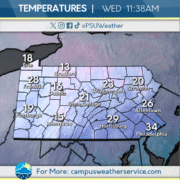
Today, light snow has been occurring across the Commonwealth with a high of 27 and a low of 15, although the wind chill puts it in the upper teens. The snow will taper off during the evening and making way for increasing winds and colder conditions this weekend.

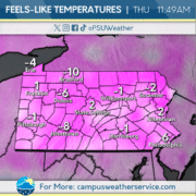
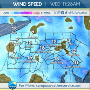
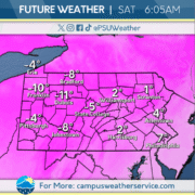
An Extreme Cold Warning is issued tomorrow and will continue throughout this weekend. Wind chill values are expected to be as low as negative 20 degrees and wind gusts up to 40 mph. These conditions will not last long as we expect temperatures to rebound early next week.
It Has To Get Worse Before It Gets Better

Over the past couple of days, the overall temperatures have been slightly warmer than usual. It’s been a nice short relief from the extreme cold and piles of snow.

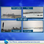
Currently, it is beginning to cool down a bit and we’ve been getting some pretty consistent sunny skies.

We’re expecting some flurries on Friday, with temperatures dropping into Saturday and Sunday, with the low on Sunday falling below zero. However, to start the work week, there will be a change in temperature trends as conditions start to warm up and will experience highs above freezing. Chances of snow are also likely on Saturday and Sunday with the east half of the Commonwealth getting around a trace to an inch of precipitation and in the west, one to two inches is likely with more snow in the upper elevations as well as the Lake Eerie area.

Sunny but Still Chilly

Conditions have warmed up slightly over the last few days but have ultimately remained below freezing. The sun has been visible, granting a reprieve from the clouds.

Today, temperatures remain in the 20s, with more sunshine brightening the area. Winds will remain light, warding off any additional chill.

As we head through the rest of the week, Friday will see the first chance for potential snow accumulation. Temperatures will drop off towards the end of the week as another Arctic air mass moves through the area.

Six More Weeks of Winter!

Our resident prognosticator, Mr. Phil, has declared six more weeks of winter! This should come as no surprise after looking out the window at the robust snowpack that has remained for over a week. After a past couple years of mild temperatures and snowfall totals, Phil’s forecast certainly seems realistic.

Despite the prediction that occurred in Punxsutawney this morning, no significant snowfall is expected in the near future. Other than a few flurries overnight tomorrow, we will have to wait until Friday for a potential couple inches of snow to accumulate.

After a frigid weekend, temperatures slowly begin to rebound closer to average with highs nearing 30, although overnight lows remain in the single digits. This warm-up will come to a crashing halt beginning Saturday as a cold front lowers temperatures back to the teens.

Arctic Air Holds Strong

The weather story in the Commonwealth has stayed as wintry as can be for the better part of a week now. One of the coldest stretches in recent memory has included consistent highs in the mid- to low-teens, subzero wind chills, and of course, our recent winter storm that dumped over a foot of snow statewide. The snowpack left behind has only seemed to make things even colder this week.

Friday looks no different. While the sun is out and the wind has let up somewhat, the arctic air mass has not, and temperatures remain stuck in the teens. Wind chills will still reach as low as -15 degrees overnight in State College, one of many absurd values in an utterly frigid stretch so far.

Hilariously, no end lies in sight until after the weekend. Temperatures begin to tick back up to near the twenties by Sunday, but wind gusts return once more as an offshore system passes. Relief comes at long last at the start of the new workweek, with highs finally climbing to near the 30 degree mark by Tuesday. One can only hope we stay there for the remainder of this long and cold winter.

Brrrrrrrrr!!!❄️

This past week has seen an artic blast move into our region. Wind Chills across the Commonwealth have been in the negatives across the state. This cold has kept the snow pack from last weekend’s storm in place.

We are expecting the cold to continue throughout the day. Wind chills across the state are expected to reach -20 in much of the state. Clouds are expected to cover the majority of the state.

Temperatures will not get any warmer as conditions will remain frigid throughout the weekend. We are also watching the threat of snow for the southeast of the state on Saturday into Sunday. Conditions will improve slightly as we get into the new week.

Frigid Digits

A weak clipper system traversed Pennsylvania throughout the day yesterday, with some across the western portions of the Commonwealth seeing a quick coating of snow. Some snow squalls in northwest Pennsylvania allowed snowfall to accumulate an inch or two. Temperatures plunged into the single digits for most across the Commonwealth, with some areas seeing low temperatures below zero.

Wind speeds between 10 and 15 miles per hour, and temperatures remaining in the teens and low twenties have lead to feels like temperatures across the state feeling well below zero. Clouds hang tough across much of the Commonwealth through the evening, with low temperatures diving into the single digits for most again tonight.

Dangerous cold is possible Friday morning across Pennsylvania, with temperatures well below zero in many spots. Feels like temperatures could be as low as 20 below zero, which could cause frostbite in under 30 minutes. Please be sure to limit your time outside and bring in any pets overnight. Stay warm Pennsylvania, the coldest air of the winter so far in on the way!

Frigid Stretch Ahead

After a winter storm impacted the Commonwealth over the weekend, a large accumulation of snow remains on the ground. Conditions remain blustery to start the week, as overnight lows remain in the single digits. A few lake effect snow bands also moved through the region on Monday night.

Well below average temperatures will persist across Pennsylvania for today. It will be cloudy throughout the day and night. Windy conditions will put feels like temperatures sub-zero during the overnight hours.

Temperatures will continue to drop, with feels like conditions remaining near or below sub-zero. Mostly cloudy skies will persist across the Commonwealth, so make sure to bundle up as you head outside.

Bone Chilling Temperatures Accompany Winter Storm

The past 24 hours have been frigid and windy as an arctic air mass emerged from Canada this week. Wind chills repeatedly reached sub-zero levels and brought snow Wednesday night. Thursday offered some relief, boasting the highest temperatures we saw all week at 37.

As the weekend kicks off, expect temperatures to be a far cry from Thursday’s above freezing theme. Overnight lows on Friday are expect to be below zero and will carry us to highs in the teens all weekend. This will set the tone for the far future, as we won’t see temperatures above freezing for the time being.

The question on everybody’s mind going into the weekend: how much snow? The answer is a little bit clearer as we write this on Friday, we cautiously predict at a minimum a foot of snow with two feet being our upper ceiling for the forecast this weekend. Heavy snow will fall all day on Sunday and linger well into the overnight hours. After it’s all said and done, the impacts to travel on Sunday and Monday will be significant.

Here Comes The Snow!

After a cold stretch and some snow, temperatures have increased this morning close to freezing, with mainly sunny skies. However, these conditions won’t last, as another cold snap will arrive tomorrow. Wind chills will drop well below 0 with temperatures lingering around 0.

Heading into this weekend, we are expecting a major snowstorm to impact the entire state, with dry and fluffier snow. Snowfall will last into Sunday night, and a few lingering snow showers are possible into Monday morning as the storm exits to the northeast. After that, the cold remains with partly cloudy skies into midweek.