Look Behind You… It’s Rain!

Temperatures over the last few days have been perfectly autumnal, with the mid- to low-50s dominating. Skies have been mostly sunny, making for great sunset viewing.

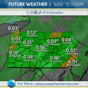
Seasonal conditions continue throughout the day today. Starting tonight, a low pressure system will bring rain to the Commonwealth. Rain will continue through the early morning hours Thursday.

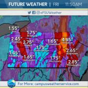
Rain on Thursday will continue and also be accompanied by stronger winds. Most of the state will see precipitation totals over an inch. The system will move out by Friday afternoon, leaving the chance for lake effect precipitation.
Cool Conditions Continue

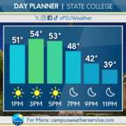
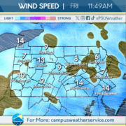
The past 24 hours in the Commonwealth have had below average temperatures. We experienced calm winds and clear skies. Similar conditions can be expected to be observed for the rest of the week.


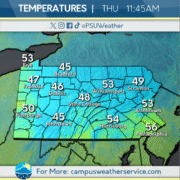
For today, we are seeing temperatures in the 50’s with sunny skies. Cloud coverage will be kept to a minimum for the rest of the day. Temperatures will drop tonight to the 40’s starting in the evening.


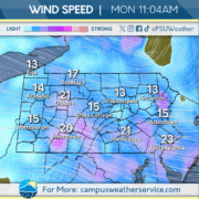
The outlook for this week shows sunny skies in the beginning of the week but cloudy skies and precipitation will start on Wednesday and continue into the up coming week. Temperatures remain in the mid 40’s to mid 50’s. Wind speeds will start off strong in the beginning of the week but will decline going into the weekend.

Breezing Through the Weekend

This week has been a roller-coaster of weather, with multiple fronts moving through bringing on and off rain showers all week. Cloudy skies have dominated recently as well as gusty conditions coming together to create a fall-like feel. It was a great week to break out the layers as conditions were relatively chilly this week.

Today sees a break from the, with isolated lake effect precipitation staying Northwest of Centre County. The clouds and breeze remains as we move through the day and temperatures stay in the low 50s.

For this weekend you can expect to see a slight increase in temperatures flirting with the mid-50s for the first time since the beginning of the week. The potential for scattered showers remains low but a few drops could fall during the weekend. Mostly cloudy skies will be the dominating weather feature of this weekend.

Cloudy Conditions Prevail

Windy, cold conditions swept through the area over the last few days after a cold front moved through. Showers made their way across the Commonwealth, bringing much needed drought-reducing conditions.

Clouds blanket the area today and chilly conditions stay put as fall finally takes hold. A slight chance of rain remains for the rest of the day.

The sun will continue to be absent over the next few days, and below average temperatures will remain. A warm front will then move through over the weekend, bringing slightly higher temperatures.

Chillier Conditions Expected This Week

We experienced unseasonably warm conditions his past weekend and had a cold front move through the commonwealth Sunday evening. This low pressure system moved off the coast yesterday leaving us with colder and windier conditions.

As for today, expect the winds to die down and temperatures to remain chilly with rain showers expected later this afternoon and into the evening. This comes from a follow-up low pressure system passing through the Great Lakes region.

The rain will be short lived, however, as high pressure lifts to our area on Wednesday and hovers above Northeast region for the remainder of the week. With that, we will expect temperatures to be below average for the rest of this week and into the foreseeable future.

Cooler Temperatures Intrude Pennsylvania

Yesterday, majority of the state saw above average temperatures with a cold front moving through later in the evening. This brought rain into the overnight hours and into early morning Monday.

Today, rain is expected to clear out for most of the Commonwealth as the cold front exits the region. The cold front leaves behind below average temperatures with winds speeds about 15-20 miles per hour.

Beyond today, temperatures are expected to remain below average, failing to emerge out of the upper 50s over the next few days. Our next chance of rain doesn’t come until early next week.

A Break from Fall

Conditions have been fall like around the region throughout much of this week. A high pressure system stationed over the Commonwealth has kept it dry and cool every day. This weather pattern will only stick around for a little bit longer as the weekend kicks off.

Friday will start off chilly and gradually warm up throughout the day. The skies will remain beautiful and sunny during the afternoon and into the evening. These conditions will continue overnight and into Saturday.

Although the weekend starts off seasonable, Saturday afternoon will bring above average temperatures. A cold front will begin to move its way through the area starting early on Sunday, bringing some showers and thunderstorms. As the front moves out of the area, the start of next work week will see the return of fall to the Commonwealth.

Seasonable Conditions This Weekend

Autumn has arrived, with fall-like conditions prevalent across the Commonwealth throughout the past few days. Temperatures have been seasonable to slightly below average.

Cloud cover will continue throughout the rest of the week, with temperatures going from seasonable to slightly above average. Temperatures will continue to rise throughout the weekend.

A low-pressure system will invade the region heading into Sunday, bringing with it chances of rain. Periods of rain may continue as the work week begins.

Sunny Skies, Average Temps

Yesterday started out overcast but the sun was able to make its way back into the sky after a couple cloudy days. Although skies cleared, temperatures remained below average for this time of the year, lingering in the upper 50s and low 60s.

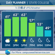
Today will start out with cloudy skies, but like yesterday, skies will clear for another sunny day, with a warm up and temperatures closer to average with a high of 63. It’s a perfect day to enjoy the fall weather and go leaf peeping!

Conditions will remain the same tomorrow, with clear skies and average temperatures. As we head into the weekend, we can expect a change as a cold front will bring cooler temperatures and rainy conditions.

Bye, Bye, Nor’easter!

This past weekend, a Nor’easter scaled up our coast causing cloudy conditions over much of the Eastern seaboard. Areas like the Jersey Shore, Long Island, and Boston experienced very heavy rains and flooding bringing danger to large populations. Luckily, the Nor’easter is coming to an end and moving east out to sea, alleviating these areas from previous damage.

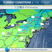
For today, cloudy skies are still expected with seasonable temperatures across much of the Northeast. A high pressure system will drop into our area from the North, clearing out those cloudy conditions and making Wednesday and Thursday more sunny. Temperatures overnight will start to drop and will approach freezing temperatures.

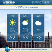
For this weekend, a cold front will come through causing for clouds to build up yet again, with very rainy conditions for much of the Commonwealth. From this, temperatures will climb back into the 70’s during the day and 40’s overnight.