Coastal Storm Brings Showers, And The Week Ahead

The past weekend saw clouds slowly roll in ahead of a nor’easter off the East Coast. A few showers were noted across the Commonwealth, and temperatures remained fall-like, if not a little warm given some areas of sun.

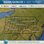
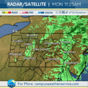
For most, Monday has had a rather dreary start. With a low pressure center situated off the South Jersey shore, widespread rain showers off the water have held steady this morning, and cloudy conditions are prevalent otherwise. Temperatures have stayed around the mid-50s and will remain there as this system passes.

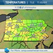
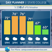
Looking past that, we can expect high pressure to set in once again, clearing the clouds by late Tuesday and raising temperatures a bit above normal for mid-October. This should make for another solid week weather-wise, with another round of precipitation not expected until perhaps next weekend.
Temperatures Fall Into Fall

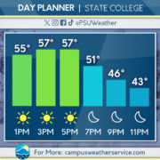
Rain showers at the beginning of the week brought with them a cold front, bringing in much cooler temperatures across the area. The wet weather ended early on Wednesday, setting up for a sunny and beautiful Thursday. As the weekend began, the first frost warning of the year was issued for much of the central Commonwealth.

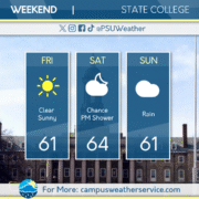
Clear conditions stick around for all of Friday. Below average temperatures continue to dominate the area, making for a chilly October day. The next change in weather will start to move its way through as the weekend begins.

Saturday will see a chance for spotty rain showers throughout the day. The rainy weather will continue for much of the weekend and into Monday morning. As the next work week begins, the seasonable temperatures will persist, and we will see the return of sunny skies to the Commonwealth.

First Freeze Friday

The past few days have seen a transition to a cooler pattern, as a cold front brought periods of rain moved through the Commonwealth. Temperatures yesterday were seasonable and skies were partly cloudy.

Today, conditions are noticeably cooler than average with lots of sunshine. Tonight, the Commonwealth could see our first freeze as temperatures head way into the 30s late overnight.

Looking ahead, a system is expected to bring more rain to the region on Saturday and Sunday. Temperatures are expected to increase to near seasonal averages.

Fall Feel Returns

Yesterday brought some much needed rain across most of the state, after a two months a relatively dry conditions. Rainfall near three-quarters of an inch fell here in State College.

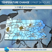
The cold front associated with bringing the rain passed through the Commonwealth today, dropping temperatures anywhere from 5-15 degrees lower compared to yesterday. Temperatures are hovering around average for this time of year.

The next couple days across the state look to be below average, with some low temperatures dipping to the freezing mark. Conditions will remain dry, as high pressure settles throughout the region.

High Pressure Dominates

High pressure situated to our north has been the cause of clear and sunny skies. The talks of rain this time last week are a stark contrast to what we have in store for this weekend. Overnight lows have started to slip further and further down, with the low temperature this morning hitting the high 30s across Centre County.


Today sees a return to the mid 70s after two days of lower high temperatures. Accompanying the higher temperatures is clear skies, with high pressure in the region resulting in sunny skies. No rain in the forecast for today also thanks to the high pressure.


Our current pattern is set to continue through this weekend, with temperatures expected to jump up into the low 80s in the coming days. High pressure will eventually exit the region middle of next week giving way to a cold front that will bring the chance for rain here in Happy Valley.

Clear, Dry Conditions Persist

Yesterday, warm temperatures dominated throughout the day with plentiful sunshine. Overnight, temperatures dropped below average.

Today started off with cooler temperatures remaining from overnight. Temperatures for today remain seasonable with clear skies as high pressure sits over the area.

This pattern will continue through the weekend, with temperatures climbing higher again towards the end of the week. Precipitation chances remain low for the near future.

High Pressure System Ushers In Dry Conditions

On Saturday, we saw light rain south of State College, bringing with it cloudy skies for Saturday night. These clouds cleared out by Sunday, leaving pleasant conditions for the second part of the weekend and on Monday. Mild temperatures expected today with partly sunny conditions, with high temperatures decreasing as we move throughout the work week. Temperatures expected to rebound into next weekend, with little to no precipitation within the next week.

Cloudy Skies, Warmer Temps

Yesterday was dry and cloudy with above average temperatures reaching 80 degrees.

Cloudy skies will continue throughout today with warmer than normal temperatures remaining.

This dry period will continue throughout the week as higher pressure dominates the region. We are not expecting any impacts from Tropical Storm Imelda.

Return Of The Rain

The past 24 hours saw very rainy conditions across the Commonwealth. The precipitation was much needed, as most of Pennsylvania is currently experiencing drought conditions. This rain was courtesy of a cold front from the Midwest. Some areas picked up over an inch of rain yesterday.

Present conditions here in Central PA feel more like fall with closer to normal temperatures today and the same is expected tomorrow in regards to temperatures. Even though we have sunny skies today, don’t expect the same for tomorrow as we are forecasting clouds to dominate the skies. There’s even a possibility of some showers around game time, but we have to see if the system moves north enough for that to happen.

Looking ahead to the latter half of the weekend and into early next week, we expect a warm up with temperatures in the upper 70s and low 80s. Sunny skies expected for Sunday, but cloudy conditions will occur on Monday and Tuesday.

Drought Relieving Rain Today, Dry for Whiteout Weekend

Heavy rain moved into the Commonwealth throughout the day on Thursday, bringing much needed drought relief. Much of the Commonwealth is experiencing Moderate Drought conditions, according to the most recent US Drought Monitor. This stretch of rainy days won’t completely reverse the drought across the region, but will reduce the impacts in Western Pennsylvania.

Rain will continue throughout the day on Thursday, with upwards of an inch of rain expected across Central and Northeastern Pennsylvania. Clouds will begin to clear overnight from west to east, with partly cloudy skies expected across the Commonwealth on Friday.

Clouds will stream back into the region for Saturday, including during the annual Penn State Whiteout game. Rain is unlikely for the weekend, but the highest chance of seeing a few raindrops will be across very southern Pennsylvania.