Gloomy and Hopefully Bloomy?

A cold front that came through last weekend caused for an interruption in nice weather to dreary, cold, and rainy conditions. This entire week we have experienced rain showers on the daily, with below average temperatures.

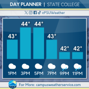
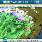
For today we will experience temperatures capping out in the 40’s. Rain is expected to come into the area this afternoon and last into tomorrow.

For this weekend, the rainy pattern will continue for Saturday, as well as chilly conditions. For Sunday, we will experience a slight warm up with partly cloudy skies to alleviate from this wet weather. To begin the work week, rain should come back into the region Monday evening and continue into Tuesday. Combined with chilly conditions, snow showers are possible on Tuesday in the higher elevations.
Rounds Of Rain Continuing

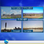
Over the last few days, we’ve seen below average temperatures and cloudy conditions. We’ve also see off and on rain showers throughout the beginning of the week. Unfortunately, that pattern looks to continue heading into the weekend.

Temperatures begin to take a slight rise throughout the day on Thursday and even more on Friday. Expect rain showers to continue throughout Thursday and clouds to stick around overnight. Enjoy the warmth at least, because that won’t stick around for long.

Heading into Sunday, we’ll start to see a break from the rain as high pressure settles over us leaving us with partly sunny skies. Monday keeps those above average temperatures around before departing us heading into the middle part of next week. We’ll start to ride the temperature rollercoaster as another system impacts us on Wednesday.

Winter Whiplash

Below average temperatures to start off the week, accompanied by some snow flurries. The past few days have felt dreary, as wintry conditions and mostly cloudy skies persist. Patches of sunshine moved through the area yesterday, with clouds dissipating by sunset.

Persisting blue skies accompanied by higher temperatures are shaping up for a beautiful spring day today.

Wintry conditions return tomorrow morning, when southern portions of the Commonwealth will see some snow showers again. As the day progresses, rain will dominate across the state, but temperatures will still remain below average. Wet and cloudy conditions make for another run of dreary conditions across the state this weekend.

Jack Frost’s Encore?

Last week’s consistent above average temperatures have unfortunately taken a swing to the other end of the ‘average’ spectrum. A cold front passed over the Commonwealth over the previous 12 hours, bringing a chilly Canadian air mass to our neck of the woods.

Today’s feel-like conditions are nearly 30 degrees below average, with gusty winds that don’t help one bit. Make sure to stay bundled and cover any exposed skin to minimize the effects of the unseasonably cold weather.

Looking ahead, the Northeast may begin to feel some temperature-relief this upcoming weekend, where conditions bounce back to what you may expect for spring!

April Showers Bring….. Snow?

Rain showers moved across the state this past weekend. Temperatures dropped overnight into Monday, bringing subfreezing conditions to many reporting sites across the state. A look out our camera to Beaver Stadium shows a pretty bleak picture!
Some areas of the Commonwealth received some sleet this morning, dragging along those dreary conditions. Misty showers will continue throughout the day with temperatures sitting just above freezing.
Subfreezing conditions will be more common tonight as compared to last night, which allows for a possibility of snow showers to many areas across the state. Some sunshine will show through as clouds dissipate later tomorrow afternoon, but not for long. This cold and wet weather is here to stay, as the rest of the week will see more rain showers and below-average temperatures.

No Sun, No Fun!

This week a large temperature gradient has brought the commonwealth unseasonably warmer temperatures and precipitation. Windy conditions passed throughout the state and lowered feels-like temperatures to seasonable averages. The middle of the week included sporadic thunderstorms.

Today, warmer temperatures remain across the state with cloudy skies and more rain looming in the afternoon to evening. This weekend conditions will be humid with occasional rain and temperatures will remain warmer before unfortunately dipping below average and continue dropping into next week.

Next week, unseasonably cool temperatures dominate the commonwealth, and a chance for some late season snow showers in the middle of the week. Expect overcast skies to continue throughout the week.

Rain, Rain, and More Rain… But At Least It’s Warm

We have been up and down on the temperature roller-coaster as of late. Over the last few days we’ve seen conditions fall below average into the 40’s and spring right back up into the mid 50’s. Our infamous beginnings to some rounds of rain showers also began yesterday, likely to continue through the rest of the week.

We’ve again seen some showers move through the state earlier this morning while temperatures are expected to remain in the 60’s today, well warmer than where we were at yesterday. Those warm conditions are expected to stick around into Friday as well as more rain showers moving in. The weekend is not looking much better as we will continue to see showers move in and out.

Rain totals are expected to reach a few inches across the state, which is much needed for some of us who have been in drought conditions. After our rainy weekend, we’ll look to dry out slightly and remain near average for temperatures. Those conditions are likely to continue heading into the next week.

Rounds of Rain Return

The Commonwealth experienced a snap back to reality on Tuesday with high temperatures at or slightly below average. Skies were clear for the majority of the day, with high clouds beginning to move in during the evening ahead of our next storm system. This system produced severe thunderstorms throughout the great plains Tuesday evening.

Showers and thunderstorms associated with this storm system will begin to move into western Pennsylvania throughout the afternoon on Wednesday, with over an inch of rain possible across parts of the region. These showers will diminish as they move eastwards, with areas of southeast Pennsylvania receiving less than a tenth of an inch of precipitation by noon on Thursday.

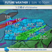
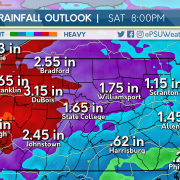
Multiple rounds of moderate to heavy rainfall will impact the Commonwealth throughout the end of the work week and the weekend. Localized rainfall amounts of 4 inches is possible along the Interstate 79 corridor by the end of the day on Saturday. Localized river and urban flooding are possible, so be sure to stay weather aware before you leave home, and remember to turn around, don’t drown.

Temperatures Drop Off a Cliff

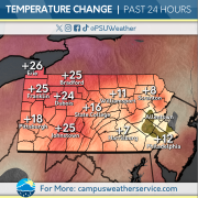
Another day, another ride on the Central Pennsylvania temperature rollercoaster ride. Down over 20 degrees from yesterday, the past 24 hours has been characterized by lots of changes in a short period of time. In addition to the temperature changes, the wind has also picked up from this time yesterday which is driving the feels multiple degrees below the actual.

Continuing on the track of a temperature rollercoaster, expect more variations in the next 24 hours. As we continue to experience fluctuations in the temperature we can expect precipitation to arrive and persist throughout the week through the weekend. Accumulation up to 4 inches in some areas is to be expected by the start of next week.

With the beginning of April past us, hold off on expecting traditional spring weather as we still have a period of cold temperatures ahead. The cold spot for the foreseeable future is a below 50 forecast for next Monday and the rain will begin to scatter.

April Showers will Definitely Bring May Flowers!

This past weekend was full of sunshine and warmer than average temperatures. Fortunately for us here in State College, we experienced plentiful sunshine this past Saturday. We also experienced a few light showers yesterday, which was a preview into the week ahead.

Today, there is a chance for thunderstorms across Pennsylvania. Stay aware and bring an umbrella. The southeast of the state is definitely in for some severe weather. Winds will pick up later today, too.

For the upcoming week, rain will not be going away! Expect showers from Wednesday into the weekend. This weather isn’t a stranger to the season, since the general trend for Spring is rain, rain, rain!