Round Two of Rainfall to Hit Pennsylvania

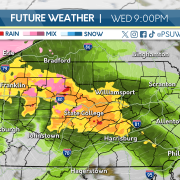
After a quick shot of rain throughout the afternoon on Tuesday, Wednesday started with mostly clear skies with temperatures above average. As the day has progressed, clouds have moved into the western half of Pennsylvania ahead of our second clipper system of the week. Areas west of the Interstate 79 corridor will begin to see rain this afternoon, and the precipitation will overspread the Commonwealth throughout the evening.

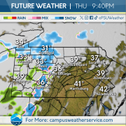
This clipper system will bring mostly rain throughout the Commonwealth on Thursday, with the northern highlands seeing some morning wet snowfall before switching to rain. A quick coating to two inches of snow is possible in the highest elevations, and travel conditions for the morning commute could deteriorate as snow begins to accumulate. The rest of the Commonwealth could see up to a half inch of rainfall from this storm system.

Friday will feature cooler than average temperatures with the chance of snow showers west of the Laurel Highlands. Some of these showers could reduce visibilities, so be sure to take extra precautions when traveling. The weekend is looking to feature below average temperatures with the chance of a light wintry mix across the Commonwealth on Saturday before skies clear for Sunday.

Above Average Temperatures Present in State College and Beyond

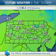
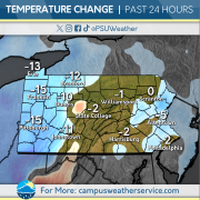
The Commonwealth has gone through a much-welcomed warming trend in the last 48 hours. Temperatures have reached the lower- to mid-40’s in most regions, and should hold steady as we progress through the workweek. With that comes chances of rain, which has already been observed early Tuesday and is being monitored for the days ahead.

The outlook for the immediate future is headlined by the continuation of above average temperatures. Expect conditions to break into the upper 40s tomorrow but also be aware of the chance for rain. Probability of rain showers should begin in the early afternoon and increase steadily as day turns to night on Wednesday. Expect overcast conditions to remain constant for the majority of the day.

An unfortunate outlook lies ahead for warmth enjoyers for the end of the week. Upper 40s temps will endure until Friday. Temperatures will then struggle to reach the upper 30s before returning to above 40 on Saturday. Sunday brings us back to wintry reality with an expected high of 30 and the chance for snow showers.

The Week Look-Ahead: Mild and Calm Weather on Tap

Most folks moving around outdoors yesterday in State College could do so without the heavy winter jackets they’ve been accustomed to for several months. Though the thermometer only peaked in the upper thirties, sunny skies in a dwindling winter season made it to be quite the pleasant day in Happy Valley. This was the case on Saturday, as well, as temperatures then were also in the mid-to-upper thirties across the region.

High pressure will continue its influence on the state today, and with southerly winds stronger than they’ve been than over the weekend, conditions will be pristine for those looking to go outside today. Highs will crest in the mid-to-upper forties across State College, and potentially even flirting with 50 as you head Southeast. This means any residual snow/ice cover on the ground should taper, especially in the ridgetops.

For tomorrow, though, rain will arrive in the early morning hours in association with a weak low pressure system. Accumulations will be minor, and temperatures across the Commonwealth will again climb to above-average.  Dry conditions will dominate throughout the rest of the work week with higher temperatures, but we have a cooler weekend in store. Temperatures will begin to drop off on Friday, and a chance of snow is possible on Saturday.

Dancing into THON Weekend

This past week we have seen unseasonably cool temperatures and scattered precipitation events. Wind speeds eclipsed 40+ mph, bringing feels like temperatures to sub zero conditions. Icy conditions remained before the sun decided to dance its way into the weekend.

This weekend, high pressure systems bless the commonwealth with sunshine and more seasonable temperatures. Friday brings the last bit of isolated snow showers before clear skies dominate starting on Saturday and continuing into next week.

Another low pressure system re-enters the Commonwealth in the middle of next week, bringing the possibility of some more snow showers in higher elevated portions of the state, and mixed precipitation to the rest of Pennsylvania.

Clouds & Cold

We started off the week fairly breezy, with gusts well into the 40’s and 50’s across the state. Those winds have since left us, but now we’re just left with abysmally low temperatures. Along with that cold air, we’ve been served with additional clouds, preventing the sun from giving us any relief from this Artic air.

Cloudy conditions for most today will continue as a disturbance moves across the state. There is the possibility to see a snow shower today, but those chances quickly drop as we dry out heading into the weekend. High pressure settles in and we’ll be left with some more seasonable conditions.

Heading into the next work week, there is a slight warm-up projected for Monday. Temperatures are expected to head into the 40’s and may even reach 50 across the southeastern part of the state. Unfortunately, those conditions will only be around for a little bit as another system bringing rain and snow showers is scheduled to impact us around Tuesday, sending temperatures back near average for the remainder of the week.

The Cold is Getting Old

There’s no doubt about it, temperatures have been low. While it may be February, the recent cold spell in Central Pennsylvania is well below average for this time of year. With temperatures in the low teens and single digits and even lower wind chills, even the most hardcore winter lovers aren’t digging it.

On tap for the next 24 hours is more cold, with a side of gusty winds. From a glass half full perspective, the immediate future will be warmer compared to the past couple of days, but temperatures will still be below freezing and not even crack the low 30s. Snow is also expected for Thursday with showers expected in the evening hours. Good news for the snow, accumulation will most likely stay at or below a tenth of an inch.

Looking further ahead to the end of the week and beyond, much higher temperatures are on the way. A little bit of hope for those who have been suffering with the current cold conditions. Temperatures in the mid to high 30s are expected for this weekend. For the start of next week expect temperatures as high as 41, providing a much needed respite. With the warmer temperatures brings a chance for rain on Monday of next week.

Hit With The Artic Blast!

We have been hit with an Artic blast, plummeting temperatures into the teens and lower 20’s. After our wintry mess we saw over the weekend, winds picked up, and I mean really picked up. Gusts across the state ranged from 50-60 mph! We have been dealing with those gusty winds since Sunday night through Monday, and have finally begun to calm down.

What we’re left with now is some well below-average temperatures across the region. Most of us across the state will be lucky to make it to the mid 20’s today, keeping the rest of us in the high teens. Luckily, we will stay dry the rest of the day today and even into Wednesday. Thursday brings us the chance for our next round of precipitation and our chilly conditions will stick around through the weekend.

Thursday could bring some round of snow showers across the region. Temperatures will continue to be below freezing, keeping any precipitation in the form of snow. After that, high pressure begins to settle in and conditions begin to warm slightly as we may see some 40’s across the Commonwealth over the weekend and into the next work week.

Rinse and Repeat: Cold and Blustery Conditions On Tap This Week


It was a wild wintry weather weekend across the state. Much of Pennsylvania experienced a combination of snow, rain, and even ice to end the day. As a storm system moved through, much of the state first saw snow that after a few hours changed over to rain. State College received around half an inch of snow before it transitioned over that evening. As Saturday turned to Sunday, rain hampered travel, but it was short lived as a cold front brought dropping temperatures and some backend snow showers for many, especially west of I-99. Much of Centre County added about a tenth of an inch of snowfall over Sunday night.

This pattern will continue today, as the wind threat will elevate across the entire state. Gusts of over 40 miles per hour are possible, leading to the National Weather Service issuing High Wind Warnings for portions of the commonwealth. Temperatures should only peak in the low-to-mid twenties in and around State College, with feels like values barely above 10 degrees.

The active weather pattern we experienced last week is in the rear view mirror, as precipitation chances are down for the foreseeable future. We’ve been watching a potential coastal storm grazing the I-95 corridor, but current model projections have this storm staying out at sea as it passes the northeast on Thursday. In lieu of that, Central Pennsylvania will stay dry, cold, and windy.

Valentine’s Day Loves The Sun

Earlier this week we saw rounds of mixed precipitation leaving icy conditions  throughout Pennsylvania. Unfortunately,  strong winds passed through much of the state dropping temperatures well below freezing. Overcast skies dominated the week before Love struck.

Valentine’s Day provides the commonwealth with abundant sunshine and a refreshing break from wintry conditions. Temperatures will continue to be in the mid to high 20s with low humidity.

This weekend two systems begin to pass through bringing early morning snow on Saturday, transitioning to mixed precipitation overnight. Sunday, precipitation continues as steady rain throughout the day before retreating in the late evening. Temperatures quickly drop overnight and into next week.

Taking A Ride On The Temperature Rollercoaster

We saw wintry conditions across the state on Wednesday as a winter storm system tracked up the coast, bringing snow, ice, and rain along with it. Temperatures hung around the freezing mark throughout the day and overnight into Thursday. We’re starting to see those temperatures elevate into Thursday, but they will again take a drop as we fall back down into the 20’s.

Temperatures heading into Thursday could reach the mid 40’s in some spots, thanks to some warm air that Wednesday system brought with it. After a few short hours with these higher temperatures, they’ll begin to crash and go below average, heading into the 20’s later into Friday. Expect windy conditions throughout the afternoon Thursday and even into Friday.

As our active weather pattern continues, we’re going to see yet another winter storm impacting the state this weekend. We’ll do another repeat of the systems we saw this week, with the weekend storm bringing snow, ice, and rain as it pushes through the state. Temperatures will again climb above the freezing mark, but heading into the start of the next work week, we’ll be getting a blast of some Artic air.