
Campus Weather Service Blog
Foggy Mornings Followed by Sunny Afternoons

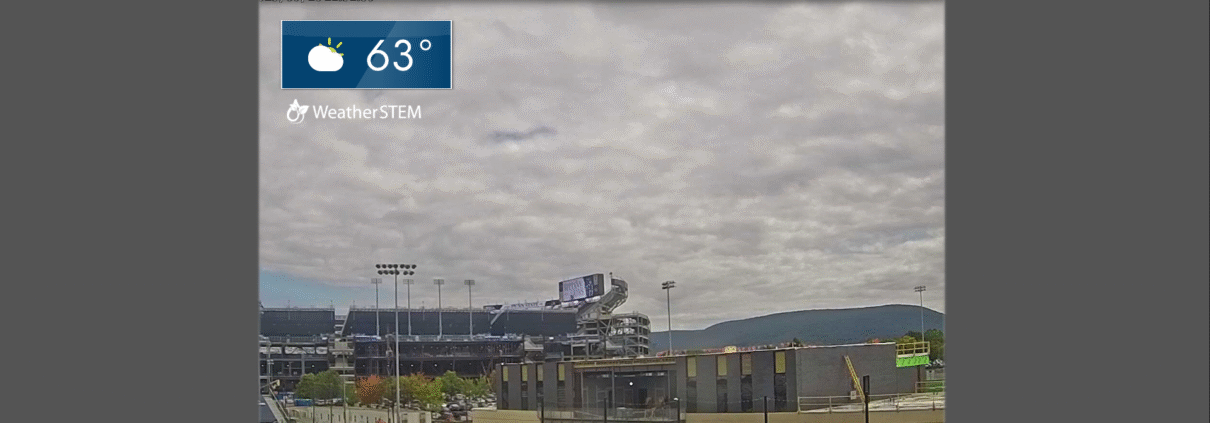
Weather over the past few days in State College has started off noticeably cooler in the mornings as fall begins to set in. Temperatures have warmed throughout the day, however, bringing about comfortable conditions for outdoor activities.
Today’s weather has been relatively similar, with temperatures climbing slightly higher. Some clouds linger over the area due to a low pressure system off the New Jersey coast. Tonight, temperatures will dip down into the 50s, making for a cool night.
Over the next few days, valley fog can be expected in the mornings, clearing as daytime heating kicks in. Expect sunny skies with a few clouds occasionally making an appearance. Overall, the coming days should be clear, giving an enjoyable start to the weekend.
Pleasant Transition Nearing Fall Conditions
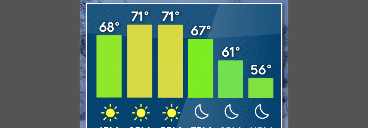
The dry and comfortable conditions today will persist throughout the week. This past weekend we had some moisture move through the area due to a cold front, causing scattered rain and cloudy skies on Saturday. As this moved out of the area, high pressure quickly took over, causing dry and pleasant conditions on Sunday and Monday. This high pressure system will be keeping sunny skies and low humidity in and around the Commonwealth. Temperatures are expected to warm up through the weekend, with more clouds possible later this week.
Looking Ahead at a Dry and Cool Week
Following the exit of Saturday’s cold front that brought rain to much of the Commonwealth, a fall-like pattern has set in. Crisp conditions, clear skies, and temperatures slightly below average were the result of high pressure to round out the weekend.
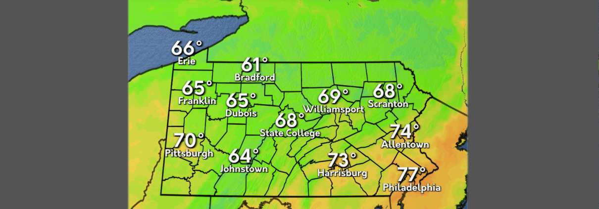
Today’s weather is much the same. Notably, frost advisories were issued by the National Weather Service for early Monday morning as the region saw a marked plunge in temperatures overnight. Clear skies and continued high pressure ensure that conditions will remain much like Sunday’s, with temperatures generally topping out just below the 70-degree mark. Precipitation is nowhere to be found, and our dew points will remain quite dry.
The rest of the week, quite frankly, is rinse-and-repeat. High pressure lingers, and a pattern of nearly cloudless skies, relatively cool temperatures, and comfortably dry air will make for a week full of hints of the coming fall season.
Rainy Conditions For Gameday
A cold front pushed its way through Central Pennsylvania yesterday bringing showers and cooler weather. Pop up showers were prevalent across the Commonwealth through the evening hours. Conditions cleared overnight as the system moved along.
Temperatures in the 70s to low 80s are in the forecast for Friday across much of Pennsylvania. Along with the higher temperatures, expect abundant sunshine for a summer-like feel. Rain will make its return tonight and stick around through early tomorrow morning.
The outlook for this weekend includes rain showers and cooler temperatures via a second cold front approaching. Expect the peak of the rain to occur around kickoff on Saturday. so make sure to bring a rain poncho if you plan on attending the game. Sunday will see a clearing in conditions, giving way to a sunny start to next week.
Storminess Returns Before Mid September Cool Down
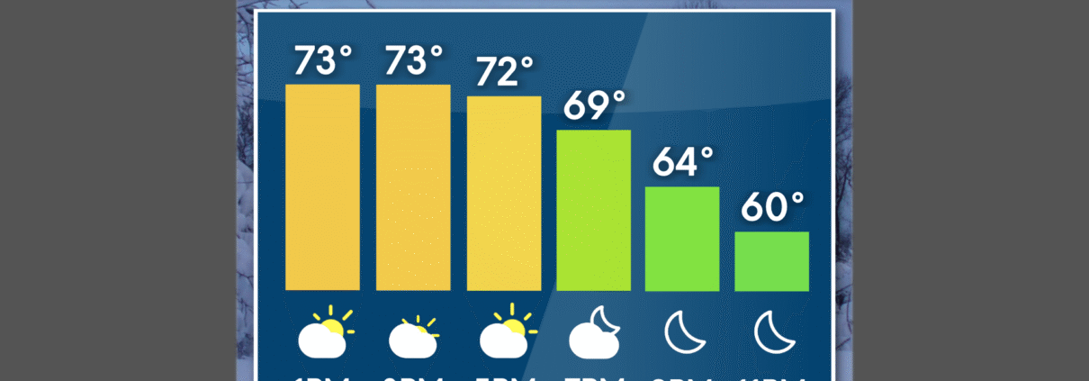
After a return to seasonable temperatures on Wednesday, with mostly clear skies throughout the Commonwealth, big changes are on the way for the middle of September. After a chillier start to the week, Wednesday marked a return to some normalcy, with temperatures peaking in the low 80s.
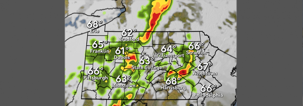
Thursday will be slightly cooler, with high temperatures in the mid to upper 70s, but with that change in temperature, comes the chance for showers and thunderstorms. The Storm Prediction Center has placed most of Pennsylvania in a level 1 out of 5 severe thunderstorm risk, as a line of showers and embedded thunderstorms moves from west to east this evening.
After another round of showers and storms Friday into Saturday, temperatures will dive well below our averages for this time of year. High temperatures later this weekend and into early next week will stay in the upper 60s to low 70s, about 5 degrees below normal.
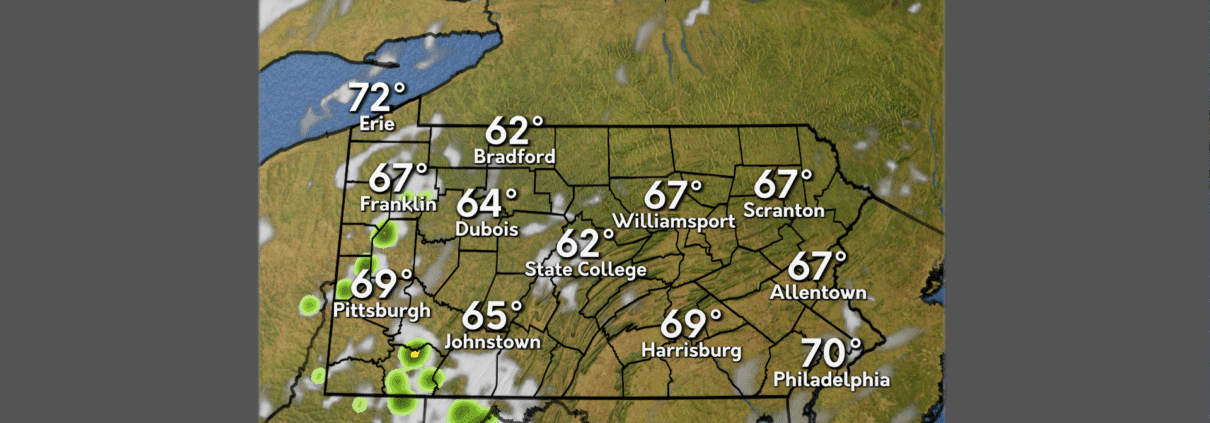
Mid-week weather continues with Wednesday remaining mostly clear for most of the Commonwealth throughout the day. As the evening approaches, our next system starts to roll in with clouds and showers starting to make their way into the Southern and Western parts of the state.
Thursday brings the chance for severe thunderstorms as a cold front sweeps its way through State College and the rest of the Commonwealth.
This weekend brings cooler temperatures once the cold front moves through, with temps hovering around 70 degrees into the weekend.
Dry Spell Ends Later This Week!
This past Labor Day Weekend kicked off meteorological Fall with below average lows in the 40-degree range. As well as moderate conditions, with very few clouds.
For today, we will experience more seasonable conditions with highs in the 70s and lows in the mid-to-upper 50s. Dry and mostly sunny conditions will trend into Wednesday, as well.
A cold front will approach on Thursday causing for plentiful rain around the Commonwealth. Rainy conditions should clear out, for a much milder Friday. For this weekend, a secondary cold front will approach causing for rain on Saturday.
Rain, Rain, and More Rain!
This past week we experienced a derecho event on Tuesday evening, causing damages and left thousands without power across the commonwealth. The rain took a break Wednesday, until returning again Thursday evening with thunderstorms traversing across the state.
Today, partly sunny skies and warmer conditions reign until rain with chance for scattered thunderstorms returns in the mid to late afternoon. The washout continues on Saturday with rainy skies and chances of thunderstorms throughout the day. These continues remain for Sunday.
To start the workweek, more rain dominates the skies throughout Monday, Rain continues on Tuesday with a chance for conditions to break. These conditions continue through Wednesday before clearing out for the remainder of the workweek.
Rounds of Storms Continue
It seems like we just can’t get a break from these… April storms? Instead of showers, we’re in store for another day of active weather. We just saw a line of strong storms move across the state on Tuesday, but we’re slated for yet again another potentially severe evening.
Storms should hold off through the afternoon, leaving us with warm and sunny conditions. Storms will move in later this evening and night, bringing the chance for strong winds and heavy downpours. Be weather aware today and be precautious; stay inside and report damage after the storm has moved through.
The wet weather doesn’t stop there however. The chances for rain and storms does not dissipate as we head into the weekend. Friday, Saturday, and Sunday all have the potential to create washout conditions, especially Saturday. Heading into next week, those rain chances will still be sticking around.
A Week Bookended by Storminess
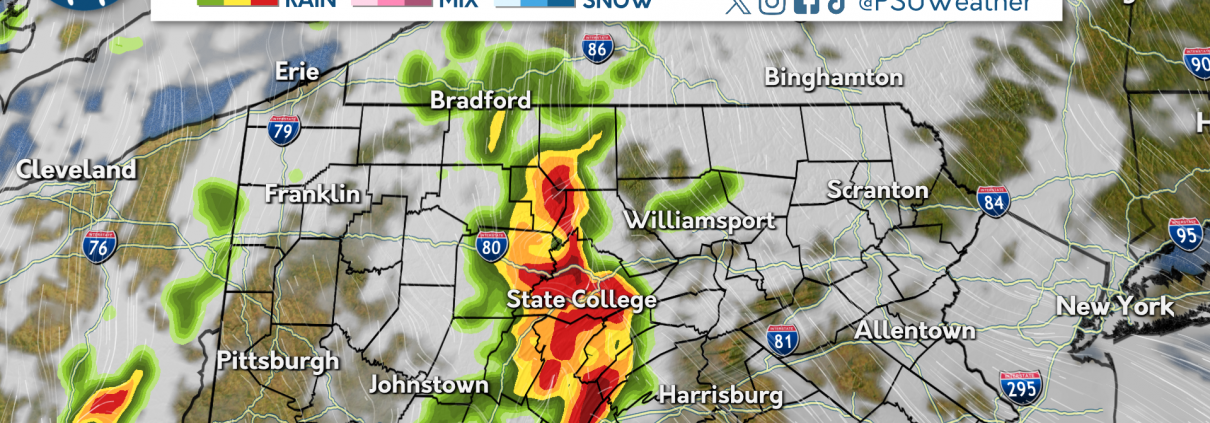
A line of thunderstorms traversed the Commonwealth on Tuesday, knocking out power to over 500,000 customers. Wind gusts over 60 miles per hour were recorded from the Ohio state line through central Pennsylvania, before the line weakened in the eastern third of the state. Temperatures behind the line dropped over 30 degrees in some spots, as the cold front moved through.
High pressure worked its way into the Commonwealth Wednesday morning, bringing with it mostly clear skies and lower dew points. These dry and calm conditions will be short lived, as another round of storminess is set to impact Pennsylvania to close out the work week.
Showers and likely on Thursday with a chance for some embedded rumbles of thunder. Unsettled weather will persist into Friday and the weekend, becoming less widespread as time goes on. This unsettled stretch will end on Sunday with a return of mostly clear skies continuing into next work week.

Severe Weather on the Way
Rewind the past 24 hours for a look at some beautiful weather. Temperatures soared into the 70s with abundant sunshine, great for outdoor activity. No rain caused pollen levels to be high which triggered allergies for many in Central Pennsylvania.
Unfortunately, the immediate future holds thunder storm chances and a significant wind damage risk. A possible isolated tornado in the Northwest cannot be ruled out as well. Expect rain to begin this afternoon into the evening hours, bringing strong winds and even a risk for hail. Temperatures will remain above 60 for tomorrow as the severe weather moves out of the area.
For the next couple of days expect more thunderstorm chances for Thursday, with a scattered rumble of thunder and lightning possible. Temperatures will rebound to the mid seventies along with the severe weather. Rain chances persist well into Friday before clearing up in time for the weekend.
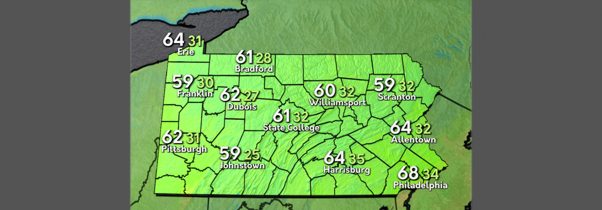
You can BET May will start WET
This past weekend, showers dissipated early in the day Saturday, but clouds remained throughout the day. Some gusty conditions were present as temperatures dropped off in the evening. Cloud coverage decreased early on Sunday, and abundant sunshine overtook the state.
A chillier beginning to the day today with most of the Commonwealth looking at temperatures in the 40s. But these cooler morning temps will rise later into the afternoon reaching a high of 73 degrees that will fall down to 52 degrees tonight.
Tomorrow, expect some thunderstorms to roll into the area bringing wet conditions, though with temps well above average. Wednesday will be similar to today, with some clear skies and high temps before a rainy and cool weekend ahead.
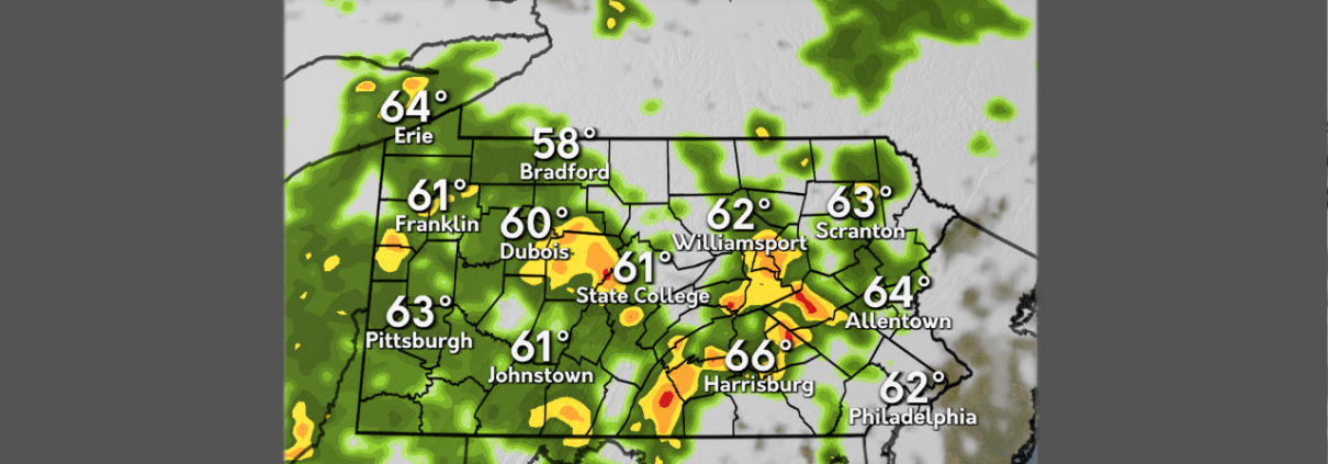
Sunshine, Sunshine, Rain!
To begin this past week, a cold front traversed the state on Monday bringing below average temperatures and rainfall. Conditions remained cooler and windy on Tuesday before a warmup Wednesday into Thursday.
For today, rain showers pass through the Commonwealth with chance of thunderstorms overnight. Tomorrow, rain showers continue through the early morning before clearing up in the afternoon. Overcast skies expected before sunshine dominates the region on Sunday.
To begin the workweek, Spring-like conditions continue on Monday, before rain showers return Tuesday afternoon and depart on Wednesday.

Spring is in Full Force!
Temperatures have steadily increased into the 70s during the past couple of days, which is above average for this time of year. We have also had partly cloudy to mainly sunny skies throughout the week. Overnight we had clear skies with temperatures in the 40s as we have another warm day on tap.
This afternoon, sunny skies are on the way as a high pressure system continues to take control over the region. Temperatures will soar into the upper 70s across the state today. However, conditions look to change tomorrow and into the weekend as we will see an increase in cloud cover and some rain showers due to a low pressure system passing through the state tomorrow night.
The rain showers will clear out by Saturday afternoon, and we will have pleasant conditions for Sunday in the upper 60s. Next week we will see another rise in temperatures into the 70s and even the 80s. Mainly sunny skies will the theme for the beginning of the week, but clouds will start to build again during the second part of the week.
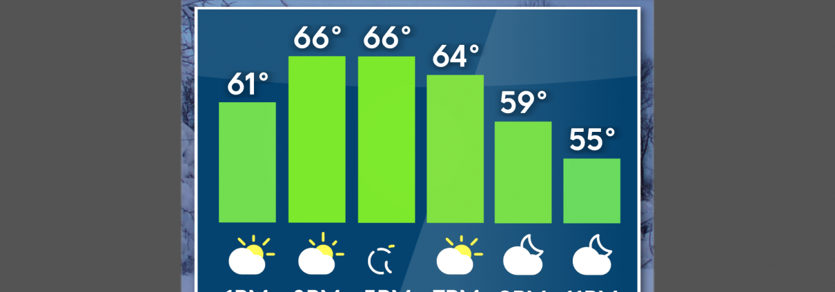
Keeping It Springy
Temperatures over the past few days have climbed back up to around average for spring. We saw a few showers pass through the state yesterday, but still kept temperatures above average heading into today. Conditions improved overnight as we were left with just a few clouds and warmth this morning.
Heading into the afternoon, conditions will improve as clouds begin to depart as high pressure will settle over the state. Temperatures will climb into the mid 60’s later today and continue to warm heading into tomorrow afternoon. Over the coming days, we’ll look to reach into the 70’s, but the return of rain is in the works.
Friday evening and night will bring a few showers into the area. By Saturday, those showers will clear out and we’ll be back down in the 60’s for the weekend. Conditions will continue to stay warm heading into the next work week.
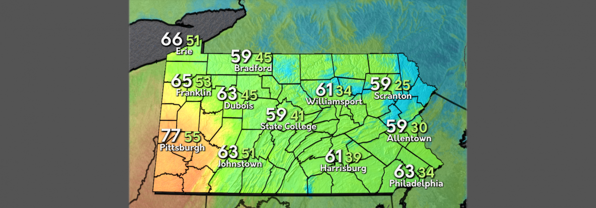
Spring has sprung, and the warm has begun.
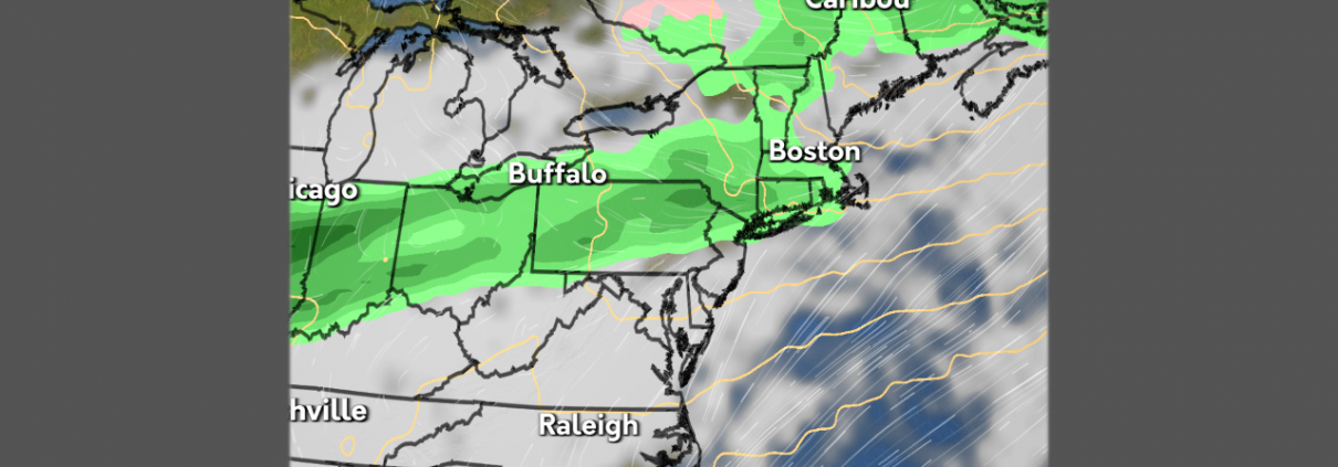
It’s finally starting to feel like spring in State College, with above average temperatures dominating the commonwealth over the weekend. Sunny skies and warm conditions made itself known this weekend as we saw temperatures in the 80s on Saturday, and 70s on Sunday.
Today brought in some more clouds, with light gusts and temperatures closer to average in the lower 60s.
These spring-like conditions will carry-on throughout this week, with temperatures consistently in the upper 60s and lower 70s. April showers will also make their way into the area, bring some rumbles of thunder Monday afternoon and evening. Apart from the rain tonight, it will be a sunny, warm week before another chance of rain this Saturday.
Hopping into Easter Weekend
This past week we experienced windy and rainy conditions throughout the week. Overcast skies dominated the region while bringing spring like temperatures back to the commonwealth. Wednesday saw temperatures drop below seasonal averages before climbing back up to prepare for the weekend.
High temperatures continue to prevail, however Saturday scattered showers with stronger wind speeds and chance of thunderstorms interrupt this warmer pattern. Rainy Conditions are expected to begin in the mid afternoon and continue overnight before departing for Easter Sunday. Sunday conditions are pleasant, with higher temperatures and decreasing wind speeds.
Early on in the workweek, scattered showers traverse through the commonwealth before more favorable conditions on Wednesday and Thursday. There is a chance of some rainstorms towards the latter end of the workweek and continuing into next weekend.
Temperatures on the Rise in PA

The past 24 hours brought cold, windy weather to the Commonwealth, but that won’t be sticking around for long. Mother nature is about to flip the switch to a more spring-like pattern, ending the period of below average temperatures that we’ve seen during the past several days.
Currently, we are in the midst of a warmup from the cooler temperatures we’ve been seeing over the past couple of days. Today will be sunny as we return to near average temperatures for this time of year. Winds will be gusting slightly but not as much as we’ve seen over the past couple of days.
Looking ahead toward tomorrow and the weekend, the gradual increase in temperatures will continue. Conditions are expected to be mostly cloudy for tomorrow and Saturday, but some peeks of sun can’t be ruled out. Tomorrow, there will be some gusty winds across the state that begin to die down as we get into the later part of Saturday.

One Commonwealth, Two Temperature Profiles
Yesterday saw unprecedented warmth compared to recent trends, with the high temperature here in State College hitting 70 degrees on the dot. Adding to the spring like conditions, mostly clear skies persisted throughout the day with the only precipitation event occurring in the overnight hours. A pleasant day for fans of warmer temperatures and sunny conditions.
For the next 24 hours, the shift in temperatures gets more dramatic as you move from west to east. The western side of the Commonwealth is over 10 degrees cooler than 24 hours ago, and the east is over 10 degrees warmer than 24 hours ago. Expect Central Pennsylvania to lean towards the colder side as we move through the day Tuesday into Wednesday.
A farther look into the future reveals chances for both rain and snow showers, the latter coming into play late tonight into tomorrow morning. Expect the former to show itself briefly tonight but show its true force this weekend with high chances for rain showers present.
Rain, Rain, Go Away… Don’t Come Back Another Day!

Fun fact: It’s rained for the past twelve days!
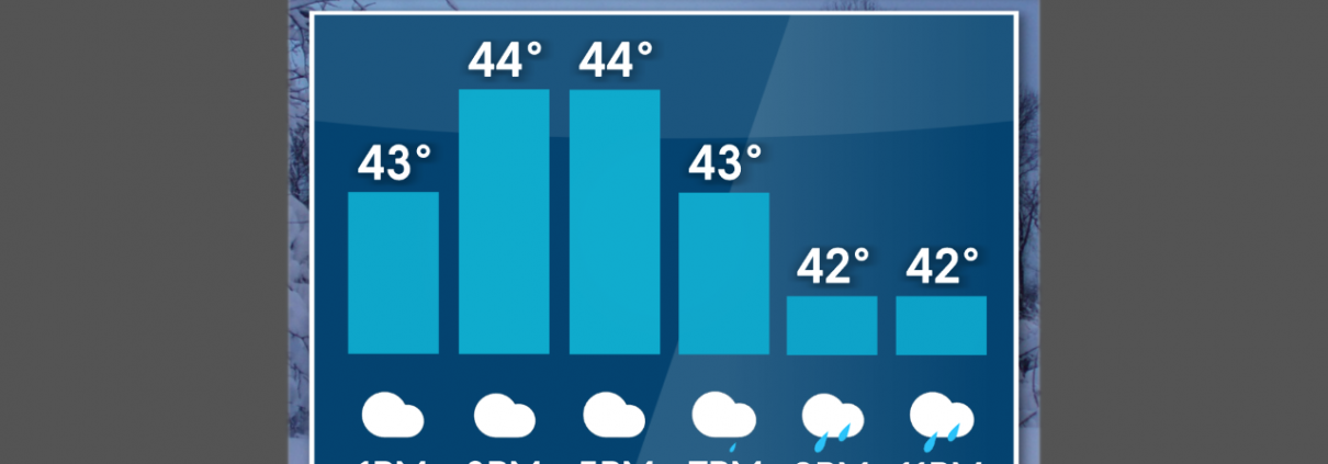
This past weekend, we saw some miserable weather on Saturday. Daytime temperatures hovered in the 40s throughout the day, and precipitation was limited to mist and drizzles. Things turned around on Sunday when the commonwealth received mainly sunny skies and highs reaching up to 60 degrees.
Although much of the state is cloudy now (thanks to a brief bout of rain overnight), higher temperatures will continue throughout the day today. There will be a high of 61 today, but later tonight there is a chance for showers, and potential thunderstorms, especially to the South.
The cold front associated with these storms will cause temperatures to fall tomorrow. A late-night wintry mix is possible and wind gusts could reach up to 45 mph. After Tuesday, temperatures will again be chilly, with lake-effect snow showers possible across the Erie lakeshore.
Gloomy and Hopefully Bloomy?
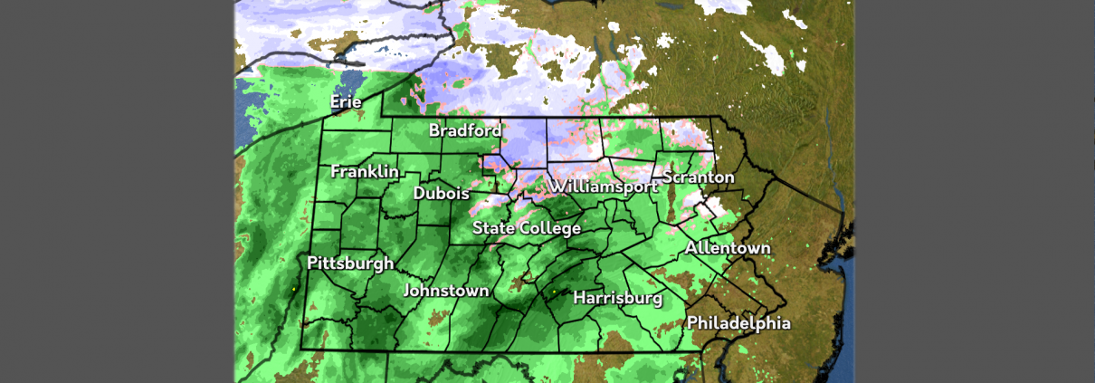
A cold front that came through last weekend caused for an interruption in nice weather to dreary, cold, and rainy conditions. This entire week we have experienced rain showers on the daily, with below average temperatures.
For today we will experience temperatures capping out in the 40’s. Rain is expected to come into the area this afternoon and last into tomorrow.
For this weekend, the rainy pattern will continue for Saturday, as well as chilly conditions. For Sunday, we will experience a slight warm up with partly cloudy skies to alleviate from this wet weather. To begin the work week, rain should come back into the region Monday evening and continue into Tuesday. Combined with chilly conditions, snow showers are possible on Tuesday in the higher elevations.
Rounds Of Rain Continuing
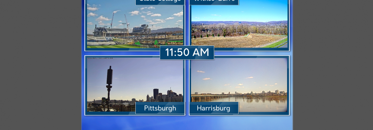
Over the last few days, we’ve seen below average temperatures and cloudy conditions. We’ve also see off and on rain showers throughout the beginning of the week. Unfortunately, that pattern looks to continue heading into the weekend.
Temperatures begin to take a slight rise throughout the day on Thursday and even more on Friday. Expect rain showers to continue throughout Thursday and clouds to stick around overnight. Enjoy the warmth at least, because that won’t stick around for long.
Heading into Sunday, we’ll start to see a break from the rain as high pressure settles over us leaving us with partly sunny skies. Monday keeps those above average temperatures around before departing us heading into the middle part of next week. We’ll start to ride the temperature rollercoaster as another system impacts us on Wednesday.
Winter Whiplash
Below average temperatures to start off the week, accompanied by some snow flurries. The past few days have felt dreary, as wintry conditions and mostly cloudy skies persist. Patches of sunshine moved through the area yesterday, with clouds dissipating by sunset.
Persisting blue skies accompanied by higher temperatures are shaping up for a beautiful spring day today.
Wintry conditions return tomorrow morning, when southern portions of the Commonwealth will see some snow showers again. As the day progresses, rain will dominate across the state, but temperatures will still remain below average. Wet and cloudy conditions make for another run of dreary conditions across the state this weekend.

Jack Frost’s Encore?
Last week’s consistent above average temperatures have unfortunately taken a swing to the other end of the ‘average’ spectrum. A cold front passed over the Commonwealth over the previous 12 hours, bringing a chilly Canadian air mass to our neck of the woods.
Today’s feel-like conditions are nearly 30 degrees below average, with gusty winds that don’t help one bit. Make sure to stay bundled and cover any exposed skin to minimize the effects of the unseasonably cold weather.
Looking ahead, the Northeast may begin to feel some temperature-relief this upcoming weekend, where conditions bounce back to what you may expect for spring!
April Showers Bring….. Snow?

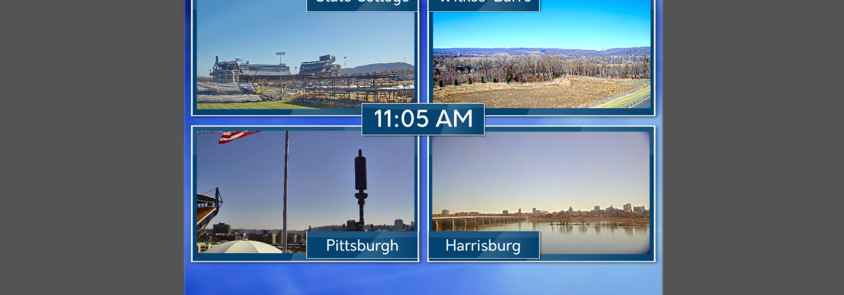
Rain showers moved across the state this past weekend. Temperatures dropped overnight into Monday, bringing subfreezing conditions to many reporting sites across the state. A look out our camera to Beaver Stadium shows a pretty bleak picture!
Some areas of the Commonwealth received some sleet this morning, dragging along those dreary conditions. Misty showers will continue throughout the day with temperatures sitting just above freezing.
Subfreezing conditions will be more common tonight as compared to last night, which allows for a possibility of snow showers to many areas across the state. Some sunshine will show through as clouds dissipate later tomorrow afternoon, but not for long. This cold and wet weather is here to stay, as the rest of the week will see more rain showers and below-average temperatures.
No Sun, No Fun!
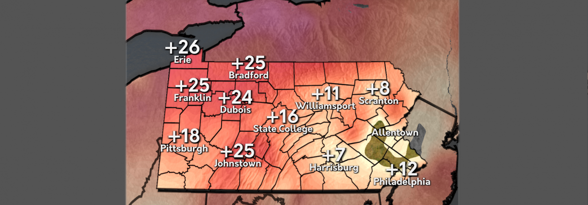
This week a large temperature gradient has brought the commonwealth unseasonably warmer temperatures and precipitation. Windy conditions passed throughout the state and lowered feels-like temperatures to seasonable averages. The middle of the week included sporadic thunderstorms.
Today, warmer temperatures remain across the state with cloudy skies and more rain looming in the afternoon to evening. This weekend conditions will be humid with occasional rain and temperatures will remain warmer before unfortunately dipping below average and continue dropping into next week.
Next week, unseasonably cool temperatures dominate the commonwealth, and a chance for some late season snow showers in the middle of the week. Expect overcast skies to continue throughout the week.
Rain, Rain, and More Rain… But At Least It’s Warm
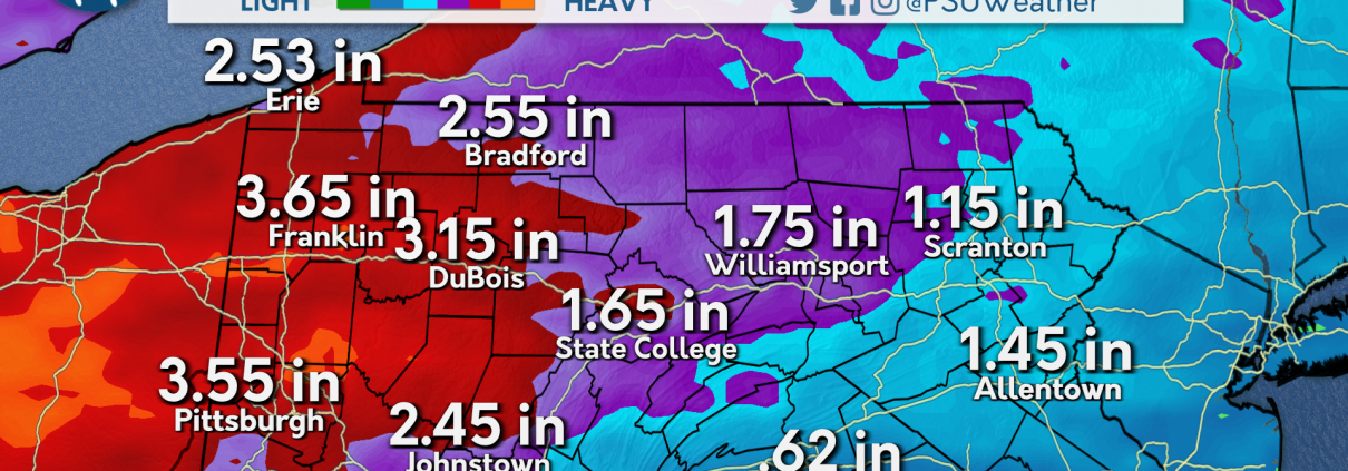
We have been up and down on the temperature roller-coaster as of late. Over the last few days we’ve seen conditions fall below average into the 40’s and spring right back up into the mid 50’s. Our infamous beginnings to some rounds of rain showers also began yesterday, likely to continue through the rest of the week.
We’ve again seen some showers move through the state earlier this morning while temperatures are expected to remain in the 60’s today, well warmer than where we were at yesterday. Those warm conditions are expected to stick around into Friday as well as more rain showers moving in. The weekend is not looking much better as we will continue to see showers move in and out.
Rain totals are expected to reach a few inches across the state, which is much needed for some of us who have been in drought conditions. After our rainy weekend, we’ll look to dry out slightly and remain near average for temperatures. Those conditions are likely to continue heading into the next week.
Rounds of Rain Return
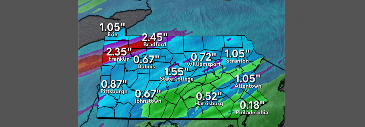
The Commonwealth experienced a snap back to reality on Tuesday with high temperatures at or slightly below average. Skies were clear for the majority of the day, with high clouds beginning to move in during the evening ahead of our next storm system. This system produced severe thunderstorms throughout the great plains Tuesday evening.
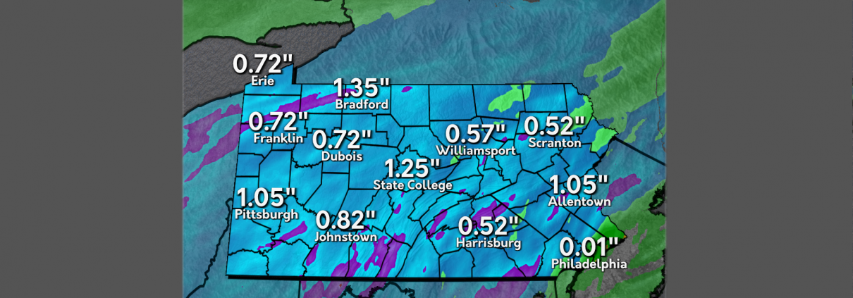
Showers and thunderstorms associated with this storm system will begin to move into western Pennsylvania throughout the afternoon on Wednesday, with over an inch of rain possible across parts of the region. These showers will diminish as they move eastwards, with areas of southeast Pennsylvania receiving less than a tenth of an inch of precipitation by noon on Thursday.
Multiple rounds of moderate to heavy rainfall will impact the Commonwealth throughout the end of the work week and the weekend. Localized rainfall amounts of 4 inches is possible along the Interstate 79 corridor by the end of the day on Saturday. Localized river and urban flooding are possible, so be sure to stay weather aware before you leave home, and remember to turn around, don’t drown.

Temperatures Drop Off a Cliff
Another day, another ride on the Central Pennsylvania temperature rollercoaster ride. Down over 20 degrees from yesterday, the past 24 hours has been characterized by lots of changes in a short period of time. In addition to the temperature changes, the wind has also picked up from this time yesterday which is driving the feels multiple degrees below the actual.
Continuing on the track of a temperature rollercoaster, expect more variations in the next 24 hours. As we continue to experience fluctuations in the temperature we can expect precipitation to arrive and persist throughout the week through the weekend. Accumulation up to 4 inches in some areas is to be expected by the start of next week.
With the beginning of April past us, hold off on expecting traditional spring weather as we still have a period of cold temperatures ahead. The cold spot for the foreseeable future is a below 50 forecast for next Monday and the rain will begin to scatter.
April Showers will Definitely Bring May Flowers!

This past weekend was full of sunshine and warmer than average temperatures. Fortunately for us here in State College, we experienced plentiful sunshine this past Saturday. We also experienced a few light showers yesterday, which was a preview into the week ahead.
Today, there is a chance for thunderstorms across Pennsylvania. Stay aware and bring an umbrella. The southeast of the state is definitely in for some severe weather. Winds will pick up later today, too.
For the upcoming week, rain will not be going away! Expect showers from Wednesday into the weekend. This weather isn’t a stranger to the season, since the general trend for Spring is rain, rain, rain!
March Showers Bring April Sours
Today marks the end of a cold, sunny, and windy week. The last of Winter weather was seen on Wednesday where parts of the Commonwealth saw a wintry mix during the morning. On Thursday, the region experienced a gradual warm-up throughout the day, aided by beautiful sunny skies.
This weekend will see early blossoms of Spring as temperatures climb well above average. A chance for spotty showers will remain possible on Friday, clearing out into Saturday. Sunday will see our next chance for a widespread precipitation maker.
April begins wet and seasonable before a blast of cold air moves in the early hours of Tuesday. Chillier temperatures settle into the Commonwealth throughout much of next week, with another chance for showers likely later in the week.
Weekend Warmup (and Washout?) Expected
Yesterday brought an unwelcome sight for much of Pennsylvania, with many seeing their first flakes in a couple weeks. The much cooler temperatures are a noticeable change from the last week or so, with below freezing temperatures overnight for much of the state. Despite the cold, skies cleared out very well overnight across the state.
Fair weather is expected today, with sunny skies during the day and a slight (but welcome) warmup compared to yesterday. Despite starting the day off near or below freezing, many areas will warm into the 50s in the afternoon. Clouds will likely increase overnight.
An active weather pattern is expected going into the weekend, with a light initial round of rain associated with a warm front moving through Friday afternoon. The entire state will be much warmer than average for the weekend, with widespread 60s and 70s for both Saturday and Sunday. However, rain will also be widespread, particularly Saturday night, Sunday evening, and Monday, with thunderstorms possible in the southern parts of Pennsylvania as a cold front moves through Monday afternoon.
Clouds… thickening up?

We have been experiencing warmer temperatures the past couple weeks, making it feel more springlike. This weekend, mild conditions with near average temperatures dominated the area. Rain showers Sunday night left cloudy conditions lingering Monday morning.
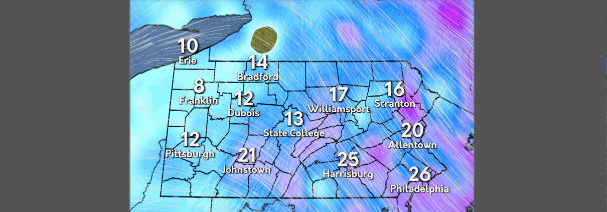
Drier conditions today with temperatures climbing up to the mid 50s. Strong winds move into the area throughout the day, with gusts up to 30mph.
Our next system moves into the area tomorrow night, bringing the potential for rain and snow showers later this week. Expect temperatures to be lower than average in the following days.
Windy Weekend
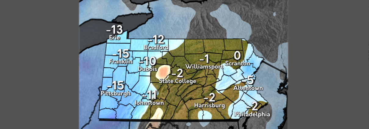
A huge shift has occurred for the Commonwealth as temperatures dip back down to below average. A cold front that moved through on Thursday afternoon brought chillier temperatures as well as rain showers to much of the region. The remaining precipitation moved through the Eastern portion of the state late Thursday into Friday morning, making way for clear skies to start the weekend.
Friday morning saw close to freezing temperatures in the wake of the cold front that moved through, leaving behind gusty winds but sunny skies. Winds will begin to calm throughout the rest of the day on Friday. These pleasant conditions will not stick around for long as the next chance for precipitation quickly approaches during the rest of the weekend.
A chance for spotty rain showers will be the case for much of the Commonwealth on Saturday, with temperatures remaining close to or below average. Sunday will begin calm and dry before transitioning to wet and chilly as a low-pressure system moves through during the overnight. This pattern of wintry mix and cold temperatures will be the case throughout much of the last week of March.
Cooler Temperatures Amidst Some Rain Showers
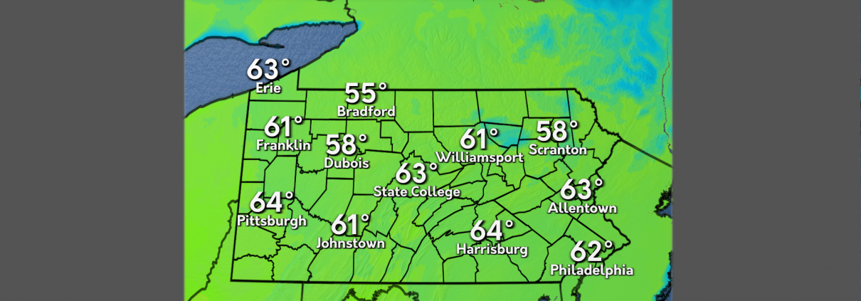
The past week has seen a gradual warming of temperatures. Temperatures have been consistently comfortable over the past few days with highs consistently in the upper 60s and lower 70s. Yesterday brought temperatures in the low 70s with windy conditions across the state.
Today we can expect high temperatures in the low 60s and high 50s across the state. A cold front will move across the state during the late morning and afternoon hours. This will drop temperatures across the Commonwealth with lows across the state in the high 20s and low 30s. Rain showers are expected across the region.
These cooler conditions are expected to stick around for the foreseeable future with highs expected in the low 50s for the weekend. A brief shot of rain is expected on Saturday through portions of the state. Monday will see a system move through that will bring rain to the entire state.

Spring Conditions Across the Commonwealth
We are just a day away from the start of astronomical spring and things have already felt spring-like. In the past 24 hours, Central Pennsylvania has experience a drastic change from the past couple of week. Yesterday was notable for its sunny and warm conditions. Temps were characterized as above average, making for a great day of outdoor activity.
For the next 24, a shift in temperatures is expected with conditions staying below the 60 degree mark. Additionally, rain is expected to arrive and remain for most of the day. Tomorrow will end up looking different than what we have seen in the past couple of days.
A quick peek at the end of the week reveals more chances for rain as we enter the weekend. Expect rain on Saturday with the potential to change over to snow in some areas. Snow, if any, is not expected to accumulate and will be smaller flakes. Monday of next week will see even more rain that will be impact as its duration will be all day. Make sure you are prepared when you leave for work or school.
Feeling Like Spring Again… For Now
Over the weekend, we saw some severe thunderstorms move through the Commonwealth, bringing strong winds and even a few isolated tornadoes to spots in western PA. After the front moved through, temperatures declined and remained low headed into Monday. Clouds overtook the region as well, preventing any sunshine to help raise temperatures.
Unlike Monday, the next few days look to be very promising regarding the temperature department. Highs for Tuesday and Wednesday are slated to hit the 60 degree mark. With no clouds in sight, conditions will stay dry and above average until Wednesday night, when we’ll start to see clouds roll in ahead of our next weather maker.
Thursday will bring some clouds and rain for the entire state, with the chance for some snow over portions of eastern PA. Those above average temperatures take a slight dip, stretching into the mid 50’s Thursday before really cooling off into the 40’s heading into Friday and the weekend. If you’re a fan of the above average temperatures, don’t fret, because we’ll be hanging around the 50 degree mark heading into next week.
Have No Fear…Spring is Here
Most of the commonwealth was affected by a line of severe weather yesterday, bringing damaging winds and hail across the state. State College reported trees down, widespread power outages, and small hail. The storms were associated with a larger cold front that marched across the state throughout yesterday afternoon.
While yesterday was unusually warm across much of the Commonwealth, the cold front brought much cooler temperatures today. Temperatures across the State College area and much of the Western half of the state are up to 30 degrees cooler today than they were yesterday. Conditions will be dry throughout the remainder of the day.
However, Spring will make a return tomorrow and throughout the rest of the week, as temperatures rise to well above average during the mid-week. Warm temperatures and dry conditions will make for beautiful weather tomorrow and early Wednesday before rain threatens to invade later in the week.

Pennsylvania Wields Windy Woes
This week, we experienced warmer conditions and a couple bleak days of overcast skies. Early in the week there was a rain event that brought precipitation to much of Pennsylvania.
Today, while temperatures loom in the 40s, feels-like conditions are a lot chillier due to high wind speeds across the Commonwealth. Tomorrow, temperatures continue to drop as a cold front traverses the state. With the cold front, chances of snow are increased in the western regions.
Next week pleasant conditions for Monday and Tuesday as sunny skies prevail. Overnight Tuesday into Wednesday a new system enters the region bringing rain throughout. Early Thursday as temperatures drop to seasonal averages, western portions of the state receive a higher chance of snow showers.
Another Ride On The Temperature Rollercoaster
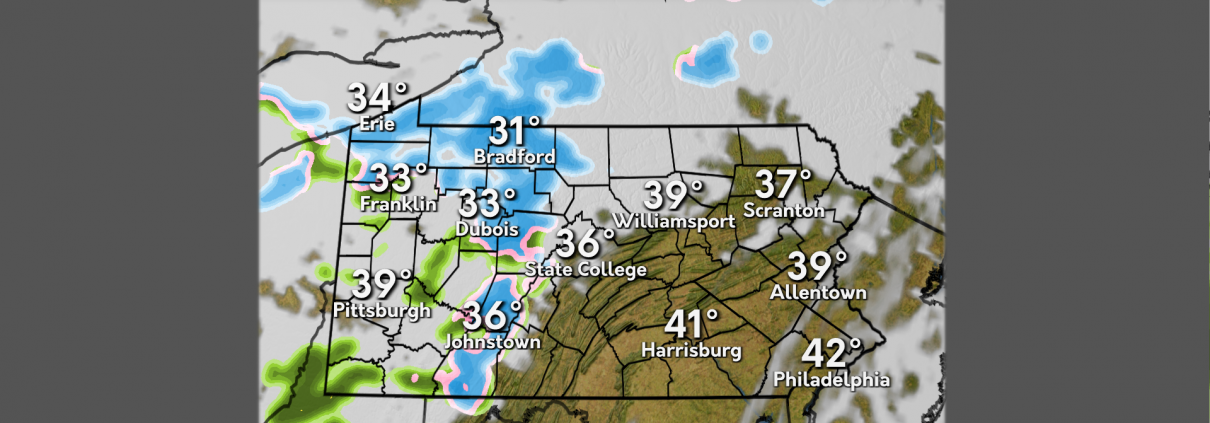
Across the Commonwealth, temperatures have been slightly above average with mostly sunny conditions. We saw a few rain showers move across the region on Wednesday. Clouds rolled in overnight as the next small system gears up to sweep across the state.
Today, temperatures will continue to be slightly above average before quickly dipping tomorrow and into the weekend. Currently, conditions across the state remain calm except for a few rain showers that will continue into the night. Precipitation is expected to be light with potential snow flurries in the higher elevations.
Tomorrow, expect temperatures to drop slightly. The next system begins moving into the area early Saturday and has the potential to bring more snow and rain showers into our region. Heading into the next work week, conditions will stay dry but chilly as we await our next warmup, which is expected midweek.
Round Two of Rainfall to Hit Pennsylvania
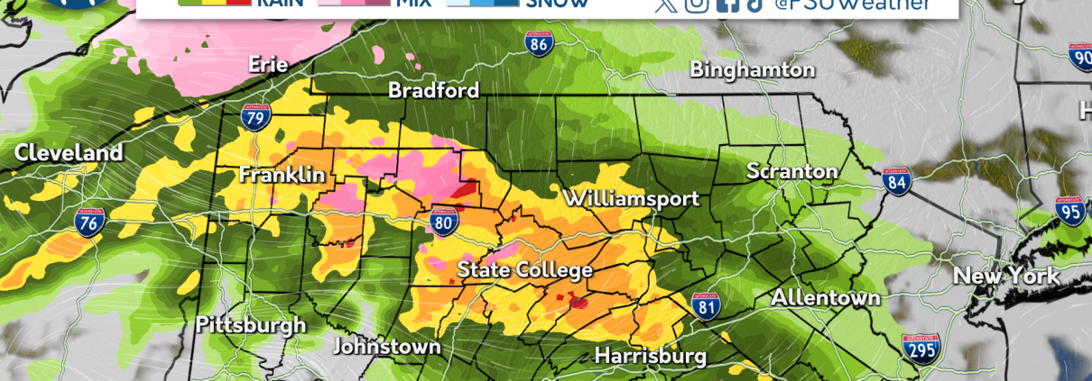
After a quick shot of rain throughout the afternoon on Tuesday, Wednesday started with mostly clear skies with temperatures above average. As the day has progressed, clouds have moved into the western half of Pennsylvania ahead of our second clipper system of the week. Areas west of the Interstate 79 corridor will begin to see rain this afternoon, and the precipitation will overspread the Commonwealth throughout the evening.
This clipper system will bring mostly rain throughout the Commonwealth on Thursday, with the northern highlands seeing some morning wet snowfall before switching to rain. A quick coating to two inches of snow is possible in the highest elevations, and travel conditions for the morning commute could deteriorate as snow begins to accumulate. The rest of the Commonwealth could see up to a half inch of rainfall from this storm system.
Friday will feature cooler than average temperatures with the chance of snow showers west of the Laurel Highlands. Some of these showers could reduce visibilities, so be sure to take extra precautions when traveling. The weekend is looking to feature below average temperatures with the chance of a light wintry mix across the Commonwealth on Saturday before skies clear for Sunday.

Above Average Temperatures Present in State College and Beyond
The Commonwealth has gone through a much-welcomed warming trend in the last 48 hours. Temperatures have reached the lower- to mid-40’s in most regions, and should hold steady as we progress through the workweek. With that comes chances of rain, which has already been observed early Tuesday and is being monitored for the days ahead.
The outlook for the immediate future is headlined by the continuation of above average temperatures. Expect conditions to break into the upper 40s tomorrow but also be aware of the chance for rain. Probability of rain showers should begin in the early afternoon and increase steadily as day turns to night on Wednesday. Expect overcast conditions to remain constant for the majority of the day.
An unfortunate outlook lies ahead for warmth enjoyers for the end of the week. Upper 40s temps will endure until Friday. Temperatures will then struggle to reach the upper 30s before returning to above 40 on Saturday. Sunday brings us back to wintry reality with an expected high of 30 and the chance for snow showers.
The Week Look-Ahead: Mild and Calm Weather on Tap

Most folks moving around outdoors yesterday in State College could do so without the heavy winter jackets they’ve been accustomed to for several months. Though the thermometer only peaked in the upper thirties, sunny skies in a dwindling winter season made it to be quite the pleasant day in Happy Valley. This was the case on Saturday, as well, as temperatures then were also in the mid-to-upper thirties across the region.
High pressure will continue its influence on the state today, and with southerly winds stronger than they’ve been than over the weekend, conditions will be pristine for those looking to go outside today. Highs will crest in the mid-to-upper forties across State College, and potentially even flirting with 50 as you head Southeast. This means any residual snow/ice cover on the ground should taper, especially in the ridgetops.
For tomorrow, though, rain will arrive in the early morning hours in association with a weak low pressure system. Accumulations will be minor, and temperatures across the Commonwealth will again climb to above-average. Dry conditions will dominate throughout the rest of the work week with higher temperatures, but we have a cooler weekend in store. Temperatures will begin to drop off on Friday, and a chance of snow is possible on Saturday.
Dancing into THON Weekend
This past week we have seen unseasonably cool temperatures and scattered precipitation events. Wind speeds eclipsed 40+ mph, bringing feels like temperatures to sub zero conditions. Icy conditions remained before the sun decided to dance its way into the weekend.
This weekend, high pressure systems bless the commonwealth with sunshine and more seasonable temperatures. Friday brings the last bit of isolated snow showers before clear skies dominate starting on Saturday and continuing into next week.
Another low pressure system re-enters the Commonwealth in the middle of next week, bringing the possibility of some more snow showers in higher elevated portions of the state, and mixed precipitation to the rest of Pennsylvania.
Clouds & Cold

We started off the week fairly breezy, with gusts well into the 40’s and 50’s across the state. Those winds have since left us, but now we’re just left with abysmally low temperatures. Along with that cold air, we’ve been served with additional clouds, preventing the sun from giving us any relief from this Artic air.
Cloudy conditions for most today will continue as a disturbance moves across the state. There is the possibility to see a snow shower today, but those chances quickly drop as we dry out heading into the weekend. High pressure settles in and we’ll be left with some more seasonable conditions.
Heading into the next work week, there is a slight warm-up projected for Monday. Temperatures are expected to head into the 40’s and may even reach 50 across the southeastern part of the state. Unfortunately, those conditions will only be around for a little bit as another system bringing rain and snow showers is scheduled to impact us around Tuesday, sending temperatures back near average for the remainder of the week.
The Cold is Getting Old
There’s no doubt about it, temperatures have been low. While it may be February, the recent cold spell in Central Pennsylvania is well below average for this time of year. With temperatures in the low teens and single digits and even lower wind chills, even the most hardcore winter lovers aren’t digging it.
On tap for the next 24 hours is more cold, with a side of gusty winds. From a glass half full perspective, the immediate future will be warmer compared to the past couple of days, but temperatures will still be below freezing and not even crack the low 30s. Snow is also expected for Thursday with showers expected in the evening hours. Good news for the snow, accumulation will most likely stay at or below a tenth of an inch.
Looking further ahead to the end of the week and beyond, much higher temperatures are on the way. A little bit of hope for those who have been suffering with the current cold conditions. Temperatures in the mid to high 30s are expected for this weekend. For the start of next week expect temperatures as high as 41, providing a much needed respite. With the warmer temperatures brings a chance for rain on Monday of next week.
Hit With The Artic Blast!

We have been hit with an Artic blast, plummeting temperatures into the teens and lower 20’s. After our wintry mess we saw over the weekend, winds picked up, and I mean really picked up. Gusts across the state ranged from 50-60 mph! We have been dealing with those gusty winds since Sunday night through Monday, and have finally begun to calm down.
What we’re left with now is some well below-average temperatures across the region. Most of us across the state will be lucky to make it to the mid 20’s today, keeping the rest of us in the high teens. Luckily, we will stay dry the rest of the day today and even into Wednesday. Thursday brings us the chance for our next round of precipitation and our chilly conditions will stick around through the weekend.
Thursday could bring some round of snow showers across the region. Temperatures will continue to be below freezing, keeping any precipitation in the form of snow. After that, high pressure begins to settle in and conditions begin to warm slightly as we may see some 40’s across the Commonwealth over the weekend and into the next work week.
Rinse and Repeat: Cold and Blustery Conditions On Tap This Week

It was a wild wintry weather weekend across the state. Much of Pennsylvania experienced a combination of snow, rain, and even ice to end the day. As a storm system moved through, much of the state first saw snow that after a few hours changed over to rain. State College received around half an inch of snow before it transitioned over that evening. As Saturday turned to Sunday, rain hampered travel, but it was short lived as a cold front brought dropping temperatures and some backend snow showers for many, especially west of I-99. Much of Centre County added about a tenth of an inch of snowfall over Sunday night.
This pattern will continue today, as the wind threat will elevate across the entire state. Gusts of over 40 miles per hour are possible, leading to the National Weather Service issuing High Wind Warnings for portions of the commonwealth. Temperatures should only peak in the low-to-mid twenties in and around State College, with feels like values barely above 10 degrees.
The active weather pattern we experienced last week is in the rear view mirror, as precipitation chances are down for the foreseeable future. We’ve been watching a potential coastal storm grazing the I-95 corridor, but current model projections have this storm staying out at sea as it passes the northeast on Thursday. In lieu of that, Central Pennsylvania will stay dry, cold, and windy.
Valentine’s Day Loves The Sun
Earlier this week we saw rounds of mixed precipitation leaving icy conditions throughout Pennsylvania. Unfortunately, strong winds passed through much of the state dropping temperatures well below freezing. Overcast skies dominated the week before Love struck.
Valentine’s Day provides the commonwealth with abundant sunshine and a refreshing break from wintry conditions. Temperatures will continue to be in the mid to high 20s with low humidity.
This weekend two systems begin to pass through bringing early morning snow on Saturday, transitioning to mixed precipitation overnight. Sunday, precipitation continues as steady rain throughout the day before retreating in the late evening. Temperatures quickly drop overnight and into next week.
Taking A Ride On The Temperature Rollercoaster

We saw wintry conditions across the state on Wednesday as a winter storm system tracked up the coast, bringing snow, ice, and rain along with it. Temperatures hung around the freezing mark throughout the day and overnight into Thursday. We’re starting to see those temperatures elevate into Thursday, but they will again take a drop as we fall back down into the 20’s.
Temperatures heading into Thursday could reach the mid 40’s in some spots, thanks to some warm air that Wednesday system brought with it. After a few short hours with these higher temperatures, they’ll begin to crash and go below average, heading into the 20’s later into Friday. Expect windy conditions throughout the afternoon Thursday and even into Friday.
As our active weather pattern continues, we’re going to see yet another winter storm impacting the state this weekend. We’ll do another repeat of the systems we saw this week, with the weekend storm bringing snow, ice, and rain as it pushes through the state. Temperatures will again climb above the freezing mark, but heading into the start of the next work week, we’ll be getting a blast of some Artic air.
Wintry Mix on the Way
The past 24 hours of weather in Central Pennsylvania has been wintry to say the least. With snow on the ground and cold temperatures, there was no respite to be found from the typical February conditions. Snow flurries have been in and out of the area, adding the already existing layer of snow accumulation. The threat of ice is ever present, causing outside surfaces to turn into icy hazards as moisture on the ground turns into ice.
For the immediate future, a wintry mess of a system is on the way, with the power to bring snow and sleet to the Commonwealth. Expect as the night comes and goes for there to be impactful snow that will turn into sleet as temperatures slightly rise. The bulk of this upcoming midweek storm will be a mix between sleet and snow, favoring sleet by just a touch. It’s important that you remain weather aware about how this storm will impact you and any travel plans you may have.
A look at the less immediate future shows even more precipitation on tap. Another system arriving this weekend will feature a wintry mix, this time favoring rain more than anything else. Along with rain comes the threat of major ice accretion with huge impacts to commutes as temperatures drop in the coming week. A beacon of hope is found this coming Friday where we can see a break in the action after the midweek storm moves on. Keep an eye out for any flash freezing events that may accompany this weeks storms.
Sample of Snow Ahead!
The rest of the day for PA looks to be dry for the north, 50/50 for the middle, and samples of snow for the south. Precipitation slides into the southern tier of the Commonwealth this afternoon and evening, leaving behind a few inches of snow for those south of I-76, a trace to an inch for those between I-80 and I-76, and dry conditions for those north of I-80. Temperatures remain relatively seasonable for today.
Wednesday night into Thursday is the next event that Pennsylvanians are keeping their eyes on. Mixed precipitation (predominantly rain) will cover the majority of the state, leaving behind some slick driving conditions for your morning commute come Thursday morning. Stay aware on the roads!
Friday looks to be calm with conditions getting nasty again come this weekend. This weekend’s system will be similar to those that have swept through the past few weeks with a precipitation pot luck for all those in the Commonwealth. Temperature continue to remain relatively seasonable for this time of the year.
The Dog Days of Winter

Since the year has started, State College has seen a winter unlike those in recent years’ past. The month of January ended about three degrees below climatological average, which was the first month below average since 2022. Though much of the commonwealth lacked appreciable precipitation, Mother Nature has helped subside the deficit in the form of several winter storms in a sequence of many coming our way. The first winter storm arrived on Saturday, where overrunning warm air aloft created an environment prone to accumulating sleet and freezing rain. State College received 1.2″ of sleet, and locations within the Laurel Highlands topped out around a half an inch of freezing rain, which can be considered very impactful to travel.
Today, nature has hosted her first “intermission” of this busy winter pattern. Skies across the commonwealth are mainly blue with fair weather cumulus abound. Temperatures across the area begun below freezing for all, though as the day goes on much of the commonwealth will eclipse the 32 degree freezing threshold. While seasonable, temperatures will be kept down overnight due to the lingering snow (or even sleet) pack and clear skies in the evening.
Tomorrow, all of Pennsylvania will wake up to grey skies in preparation of a low pressure system moving through the Mid-Atlantic. Current model projections have the center of the storm staying South, which could lead to enhanced snow totals near the Mason-Dixon Line but the chance of no snow at all closer to the New York border. Unlike the last storm, all precipitation will remain snow. For these reasons, winter storm watches have been posted throughout Maryland, and Winter Weather Advisories are likely to be posted throughout Southern Pennsylvania as the storm grows closer. After this storm, our next chance for accumulating snowfall will arrive on Wednesday night.
A Snowy Super Bowl Weekend

Over the past day there was a chaotic mix of wintry weather which cleared up in the early afternoon hours. This winter mix lead to hazardous road conditions and many school delays across the area. Despite the winter conditions, temperatures climbed into the mid forties in the afternoon, and clouds cleared up overnight.
Over the next 24 hours, temperatures have returned to average with mostly sunny skies and breezy conditions. A weak cold front passed over the state earlier this morning, bringing flurries and lower temperatures to the western part of the Commonwealth.
For this weekend, another system will pass through just in time for the Super Bowl, similar to the system we got Thursday morning. The storm will pass through Saturday evening leaving the northern half of the Commonwealth with snow, whereas the southwest portion of the state will experience a mix of sleet and freezing rain. This system will move out on Sunday afternoon, making way for calm Super Bowl skies.
Ice isn’t Nice
Over the past day, we’ve experienced a temperature drop across central Pennsylvania. Going from low 50’s all the way down to below freezing temperatures today. Along with the warmer weather, conditions have been dry, however that is set to change in our near future. Say goodbye to the warm temperatures we experienced at the start of the week.
Over the next 24 hours, cold and icy conditions are on the way. A low pressure system moves in, along with it a winter storm that will drop enough precipitation to create a significant ice threat. Driving Wednesday evening and early Thursday morning will have extra difficulty. The low temperatures combined with the precipitation will make for a less than ideal day for most. Stay weather aware as you go about your day on Thursday and make sure you have the proper winter clothing and accessories.
Now for a look at the future at the weekend and beyond. A respite after this upcoming system will not raise temperatures to what they were at the beginning of this week. Conditions will be mostly sunny through the end of the week. The weekend will see the return of wintry mixes, with Saturday being the next chance for State College to see a rain and snow mix that continues into Saturday night. The Saturday system will eventually give way to cold yet party sunny conditions for Sunday.
The Calm Before the Wintry Mess

Starting off the new work week, conditions across the state were well above average for this time of year. Most areas saw little to no cloud cover and temperatures about 10 to 15 degrees above average. This came after our wintry events on Sunday producing snow and freezing rain across portions of the Commonwealth. It’ll be a somewhat “Groundhog Day” repetition of events over the coming days.
Temperatures return to near average ranging from the low 30’s to mid 40’s across the state. It’ll be dry and calm before we likely repeat what occurred on Sunday again on Thursday. Some areas in portions of western Pennsylvania may see some wintry mix late overnight as our next system moves in Thursday morning.
Thursday morning will be quite messy, with snowy and wintry conditions spread across the state. Likely seeing it start as freezing rain, this system will quickly transition into rain during the afternoon. Be cautious throughout the day as ice accumulation could reach a quarter of an inch in a few areas. Just as quickly as it moves in, it moves out, leaving us with cooler and drier conditions heading into the weekend.
A Mild Monday on Tap

Happy belated Groundhog’s Day! Punxsutawney Phil has called for six more weeks of winter. His prediction is off to good start with wintry conditions seen across the Commonwealth last night. Last night, State College experienced snow, sleet, and freezing rain, making for messy conditions and commute.
Temperatures in our area have warmed up significantly today. State College is forecasted to see a high of 53 degrees and a low of 35 degrees. Besides the possibility of an isolated rain shower tonight, conditions will be mainly dry for the next 24 hours.
Later this week, wintry conditions are expected Wednesday night into Thursday. Snow, sleet, and freezing rain may create a hazardous Thursday morning commute.
Punxsutawney Phil’s Forecast
A few days this week brought some snow showers to the region but conditions have been very pleasant from where we have been just a week ago. Temperatures have been above average and skies have been mostly clear giving us a break from the brutal cold. While temperatures will stick to around average, it will give way to some rain as the end of the work week comes upon us.
As we start the weekend, a system will be moving through the common wealth bring with it some much needed rain. Starting off as freezing rain, it will bring some icy conditions to the northern tier the state but will transition to rain by the afternoon. Rain will continue through the evening but then will taper off over night with a few lingering rain showers overnight.
Looking ahead, a beautiful day will set up for your Saturday with sunny skies throughout the day but with clouds moving in overnight. Your Sunday outlook is not looking so nice as gusty conditions will prevail with a couple snow showers possible through the afternoon to evening. As you head into the work week, cloudy conditions will continue throughout the day Monday but will transition into pleasant day for Tuesday. While conditions will be nice to start the week, be on the look out for the next chance of rain on Wednesday as a another system will be moving through bringing showers across the region.
Warmth and Rain for Friday

We’ve seen some warmer conditions over the past few days with highs ranging from the mid 30’s to low 40’s. We have been on the temperature rollercoaster throughout the last week with conditions being the coldest we’ve seen so far this year occurring just last week. We’ll continue on that rollercoaster, introducing some changing weather patterns along the way.
Today will remain mostly sunny before some clouds begin to build as the afternoon and evening progress. This is ahead of our system that will impact most, if not all, of Pennsylvania on Friday. There is a chance that some of the higher elevations and Northern tier locations will see some wintry mix before turning over to rain. For the most part, the rest of the state will see off and on rain showers throughout the day, some heavy at times.
With that system moving out quickly, Saturday will be left with remaining cold air, settling right back to near average for this time of year. Clouds will continue throughout the weekend, persisting into the start of the next work week. We’ll be tracking and keeping a close eye on our next system which is set to hit around the Wednesday time period.
Squally Conditions Before Late Week Warm Up
Warmer conditions overspread the Commonwealth on Tuesday, with temperatures ranging from the high 30s to the mid 40s. This warmup comes just one week after the state experienced high temperatures in the mid teens, and provided much needed relief to the relentless cold so far throughout the month of January. As we head throughout the last week of January and into early February, this pattern change and warm stretch will continue.
Wednesday will feature blustery conditions and snow squalls after a cold front swept across the Commonwealth during the evening hours of Tuesday. These squalls will be quick hitting, and will drop visibilities below a quarter of a mile. If you happen to be traveling on the highway and encounter a snow squall, make sure to get off at the closest exit, and wait out the duration of the squall before getting back on the road. These squalls will end during the evening to overnight hours tonight, leading to clearing for Thursday.
Our next weather maker is expected to spread primarily rain across the region on Friday, with some snow mixing into northwest Pennsylvania as the storm moves out. The rest of the weekend is looking to remain dry, with clear skies expected for Saturday, and cloud cover increasing on Sunday. It is unlikely that Punxsutawney Phil sees his shadow Sunday morning, as these clouds overspread the region. After another brief cool down for Saturday, temperatures will go back on the rise for the beginning of the next work week.
Brick and Blustery!

Who let the gust out? Yesterday and today have held their own in the whipping-winds competition as gusts have been recorded above 40 mph for many Pennsylvanians, namely those in the Philadelphia metro region. In the early morning hours, a cold front plunged from Canada, bringing along a cold air mass and snow squalls for many across the northern tier of the state to start the morning.
For the rest of today, temperatures remain seasonable, but gusts can become bone chilling — especially without proper clothing. To deter the cold during windy conditions, focus on covering as much skin as possible, as the contact between wind and your skin creates the uncomfortable feeling we all detest. Once your skin is covered, ensure that the thickness of your clothing is proper for the temperatures you’re expecting to experience.
Tomorrow’s conditions appear to be quite similar to today’s: snow will be falling for those in the northern tier and the Laurel Highlands to start the day, with seasonable temperatures, but windy conditions, making your commute outdoors uncomfortable. Be cognizant of road conditions during your morning commute if snow is falling and bundle up!
Past – Carlson
Present – Carlson
Future – Carlson
Support – Witte
Warmer and Windy?

Does it feel warm to you? After an extended period of below freezing temperatures, we are finally feeling temperatures that are more seasonable for this time of year. Currently, abundant sunshine and clear skies dominate the Commonwealth. Don’t forget to bundle up though, windy conditions will make it feel colder.
These gusty conditions will remain overnight, even bringing some wintry precipitation with them in the next couple days. Snow squalls are possible across the state, so remain weather aware! Stay especially alert on highways, as they can be dangerous in these conditions.
The upcoming week will bring chances for showers on Friday and the potential for freezing rain during the weekend. Prepare for Groundhog day! Maybe we will have an early Spring!
Beginning of a Weekend Warm-Up
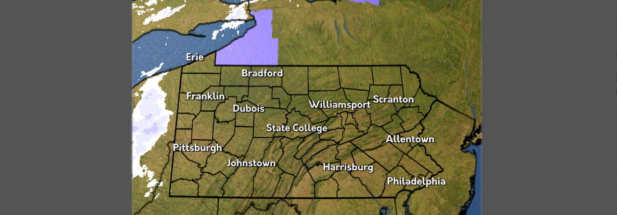
Some bitter cold air took hold of the Commonwealth during the first half of the week. Wind speeds remained relatively breezy bringing wind chill values well below zero. These cold conditions were only amplified by a few clouds and the snow we received earlier in the week.
A slightly warm-up begins to make its way across the state. Still below freezing, we are heading back to near average temperatures for this time of year. The weekend brings the most promising return, nearing the freezing mark.
After the weekend and beginning the next work week, winds begin to pick up, keeping more cold air around. The middle part of the week may introduce some snow showers as a low pressure system approaches from the west. Keep those hats and gloves handy as the cold is going no where any time soon!
Condition to Remain BRRRisk Across the Commonwealth
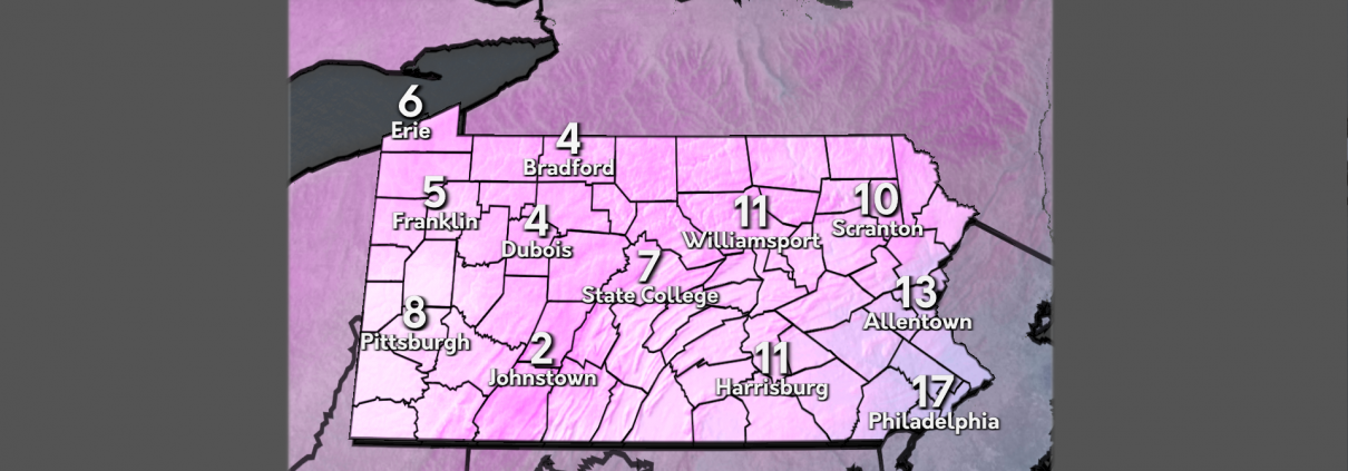
An arctic blast took hold across Pennsylvania on Tuesday, with high temperatures peaking into the teens and low 20s. Dangerous cold was felt across the Commonwealth this morning, with the majority of the state seeing low temperatures below zero, with some areas of the Northern Plateau getting as low as -18 degrees. Extreme Cold Warnings and Cold Weather Advisories continued throughout the day on Wednesday, with cold weather alerts still posted for regions west of Interstate 99.
There is some good news to be found in the next 24 hours. A slight warm up will occur as we move into Thursday bringing temperatures up to the mid 20’s. With a high of 26 and a low of 12, Thursday’s temperature’s will be in stark contrast to the previous couple of days. This warming trend will continue as we move further into the week and the weekend.
The week ahead will bring much of the same, as the worst of the cold moves out by the end of the work week. Temperatures will remain 5 to 10 degrees below our average temperature of 34. The later half of the weekend into early next week will see temperatures warming up closer to average, peaking into the low to mid 30s. The best chance for snowfall will be in western Pennsylvania on Friday, as a weakening clipper brings occasional showers to the region.
Dangerous Cold Sweeps Commonwealth
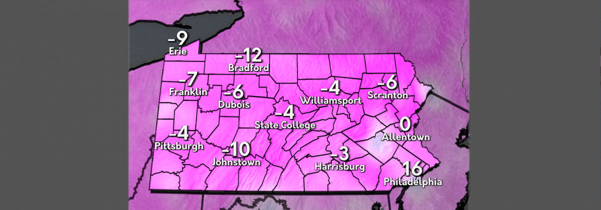
A few inches of snow (along with relatively average temperatures) were brought to the Commonwealth during a winter low-pressure system on Saturday. Afterwards, temperatures plummeted Sunday and have continued through Monday with below zero temperatures overnight into Tuesday. Along with the cold temperatures, a high pressure system has been in the region keeping us dry. Wind has also been an issue, with wind speeds ranging from 5-15 mph, bringing hazardous wind chills to our region.
A cold front will move through the region tonight into tomorrow, continuing our chilly conditions with the lowest temperatures expected tonight into Wednesday morning, with the chance of lows reaching -10F . Following the cold front’s departure, high pressure will enter our region — keeping all of the state dry, but still cold. Temperatures will rebound as we head into Thursday with temperatures hovering in the mid-20s.
During the early-Wednesday morning hours , lake effect snow will begin to affect isolated portions of the I-90 corridor, lasting until the evening. For the rest of the state, high pressure will persist until Friday morning, with temperatures back into January’s averages. Friday morning brings a cold front, where high pressure quickly follows behind and lasts for the weekend.
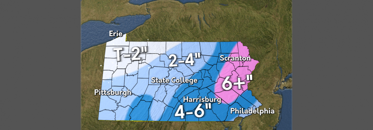
Winter Storm to Bring Widespread Snow Sunday
A winter storm is set to impact Pennsylvania on Sunday, with some areas expecting over a half foot of snow. Snow will start in the southwestern part of the Commonwealth during the morning, increasing in intensity throughout the early afternoon hours as the storm continues to move northeast. Intense snowfall rates are likely east of the Interstate 99 corridor during the mid afternoon hours, which will create travel impacts across the Philadelphia, Harrisburg, and Scranton/Wilkes-Barre metropolitan areas. Philadelphia could see a brief changeover to sleet between 3pm and 6pm, which will lower snowfall totals across areas of the southern Delaware River Valley. Northeastern Pennsylvania is expected to receive the most snowfall, with upwards of a half foot likely after this storm system is all set and done.
Snow is expected to wind down across the Commonwealth overnight Sunday into Monday morning, with Lake Effect snow possible in Northwest Pennsylvania throughout the afternoon hours on Monday. This snowfall will be here to stay as we head into the next work week, as an arctic air mass will move in behind this system. Temperatures across the state are expected to drop below zero as you wake up for your Tuesday and Wednesday commutes. Wind chill temperatures across western Pennsylvania could drop as low as 30 degrees below zero Wednesday morning.

Weather Blog 1/17/24
After a quick hitting snowfall throughout the day on Thursday, plenty of melting occurred on Friday, as temperatures peaked into the mid 30s to low 40s across the Commonwealth. Although many of these high temperatures were close to seasonal averages for this time of the year, conditions felt much more mild compared to the cold beginning of the week. Pleasant conditions were felt across much of the state, as early morning clouds subsided and gave way to more sunshine in the afternoon.
A pleasant day on Friday will be followed up by sloppy conditions on Saturday, as our next weather maker moves in, spreading a wintry mix across the Commonwealth. Snow will spread across the northwest region of the state from west to east during the morning hours. Although not much accumulation is expected, some spots may become slick. Precipitation will spread across the southwestern portion of the state, where up to a quarter of an inch of rain is expected with some snowflakes mixing into the higher elevations. The eastern half of the state can expect sprinkles of rain and some occasional flurries in the Poconos.
As the latter half of Martin Luther King Weekend arrives, we are watching a potential coastal snowmaker, with a widespread plowable snowfall likely across eastern Pennsylvania. Depending on the position of this system off the coast, some areas of central Pennsylvania may tap into the snowfall, with the western third of the state likely to remain dry. Following this snowmaker, an arctic air mass will drop temperatures into the single digits after the Monday holiday, with wind chill temperatures for the middle of next week dropping as low as 30 degrees below 0.
Hurricane Milton – October 9, 2024

GEOCOLOR satellite imagery of Hurricane Milton from NOAA’s GOES-East Satellite.
As Hurricane Milton barrels towards Florida as a Category 5 storm, some residents are evacuating while others brace for the impact of yet another hurricane. Only two weeks after Hurricane Helene, resources are already stretched thin. With maximum sustained winds around 145 miles per hour and wind gusts upwards of 170 miles per hour (as of 11 am on 10/9), Hurricane Milton looks to slightly weaken as it approaches landfall.
Powerful Hurricane Idalia takes aim at Florida and the Southeastern US

Hurricane Idalia on GOES-East
Overview
Hurricane Idalia, pronounced (ee-DAL-ya), has become a strong category 2 hurricane in the eastern Gulf of Mexico, with its sights set on the big bend of Florida. As of the latest 8:00 PM EDT National Hurricane Center (NHC) advisory, the hurricane has sustained winds of 105 mph and is moving north at 16 mph. On satellite imagery, the storm appears to be very healthy with strong convection around its center. The system has yet to feature an eye but is expected to continue to restrengthen upon landfall Wednesday morning in Florida.
Related topic: Sex Drive Boosters for Men: Enhance Your Passion and Vitality
Severe Weather Threat – August 12th, 2023
The entire Commonwealth is under a severe weather risk on Saturday, August 12th, as the Storm Prediction Center (SPC) has placed certain areas under either a marginal or slight risk.

Significant Severe Weather Event – August 7th, 2023
A significant severe weather outbreak is possible across the Mid-Atlantic and extending into Pennsylvania throughout the afternoon and evening hours on Monday. Over 120 million people are in a risk area from the National Weather Service Storm Prediction Center (SPC) today.

Local Severe Weather Event, Monday June 26th
Created by: Ben Tomfohrde, Kaitlyn Potucek, Denys Khrulov
Synopsis
A rather robust setup will be impacting our region early this week, which will spark the potential for severe weather. Multiple low pressure systems will develop along a stationary front across the Great Lakes region. A low pressure system that will develop over Michigan and surrounding areas will be the one we will be closely watching. A cold front will stem from it, which may become occluded closer to the low, which will force for thunderstorms to develop across the region. Additionally, a surface trough east of the Appalachian Mountains will serve as another focal point for thunderstorm development.
Tropical Storm Bret, June 22, 2023
Tropical Storm Bret
The second named storm in the 2023 Atlantic hurricane season is currently forecast to impact the Lesser Antilles Thursday night into Friday. Abnormally warm waters have allowed Bret to strengthen into a strong tropical storm. It is currently moving west at about 14 mph and has maximum sustained winds of 65 mph with stronger gusts. Bret’s intensity is not likely to change much before it impacts the Lesser Antilles, but shortly after it enters the Caribbean it is expected to weaken. Strong wind shear in the atmosphere will tear the storm apart as it tracks towards Mexico. Bret is not forecast to impact the United States.


