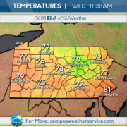
Temperature See-Saw

This past week we have seen some gloomy conditions. The past few days have been mostly overcast skies with scattered showers and below-average temperatures. Today, expect to see sunny conditions in the early afternoon with clouds rolling in throughout the evening. Scattered showers predicted to appear in the mid-to-late evening.
Leading into the weekend, temperatures will slightly drop with persisting clouds lingering from the week before. Highs will be in the upper 50s with lows expected to reach the upper-to-mid 40s. Next week will see an increase in temperatures and clearer conditions, allowing for sunshine to shower the area.

Rain on the Way

Yesterday, we had some pretty chilly weather come through the commonwealth with temps in the 50s much across the state. This is because a cold front is coming through the area. Not only is it bringing some chillier temperatures and conditions but yesterday brought some scattered rain showers.

These rainy conditions will be more prominent throughout the state today with heavy rainfall and thunderstorms possible today. The rain will continue through the early afternoon today into the overnight hours into Thursday.

Temperatures remain chillier than usual tomorrow and into the weekend but the main thing is we are mostly dry throughout the period but maybe a stray shower or into on Friday.

Feeling Like Summer!

Yesterday, above average temperatures along with lots of humidity, which has resulted in the formation of thunderstorms across the region. The humidity also created feels like temperatures that feels even warmer than the already well above average air temperatures. Sunny conditions were present for most of the day other than the occasional pop up storm.

Today, above average temperatures will continue along with a chance of storms, and some strong storms to the north and west. Despite the chance for rain, sunny conditions will persist for most of the day.  Also, like yesterday, the humidity will he high, creating warmer and sweaty conditions.

For tomorrow, well above average temperatures will continue with the chance of a small shower or thunderstorm. Similar to today, sunny conditions will be present for most of the day. Stronger storms will be possible for Saturday along with above average temperatures.

A Calm and Cool Week

The beginning of this week saw some unseasonably low temperatures across the Commonwealth, with gusty winds exacerbating these temperatures. Tuesday brought the worst of the winds, yet also some beautiful sunshine that was absent from the previous few days.


Today sees similar conditions as Tuesday, though with temperatures climbing and winds calming. A high pressure system looming over the state will keep the rain away as a cold front approaches.


This high pressure system will give way to a cold front that will move through on Friday, bringing rain and wind throughout the Commonwealth. Temperatures will reach a high by the end of the week as clouds dissipate and finally bring some spring conditions.


Rain, Rain, More Rain!

Yesterday we had on and off sun showers with above average temperatures. Overnight, a system came through washing out the entire state. Throughout the state, we saw quite the anomaly in temperatures yesterday with Erie in the 30’s and Philadelphia up in the 80’s.

For today, expect isolated showers throughout the region, with temperatures in the 40’s to 50’s. Overnight, another low pressure system will pass to our northwest bringing in showers to the western half of the state. Tomorrow, temperatures will rise and peak in the 70’s and with that thunderstorms will be likely in the late afternoon. Showers will then take over in the late night hours.

The rain will continue into the weekend, as a large cold front passes through the entire state, before eventually clearing out Sunday afternoon. Next week should be more pleasant with less rain and more sun!

Big Temperature Variation

Yesterday, the Commonwealth saw a small warmup in temperatures with highs remaining in the high 40s. That trend is continuing today and tomorrow with a major jump today to the mid to high 50s and tomorrow we can expect temperatures to possibly hit over 70 degrees. Tomorrow night is where the warm up ends as rain showers with possible thunderstorms roll in through the commonwealth with potential for those thunderstorm to be severe with a marginal risk for western PA. If the thunderstorms do become severe, expect damaging winds and small hail. Those showers are going to be along a cold front where temperatures will drop back to a more chilly range with these temps being highs of mid 40s as we head into the start of the weekend.

Weather Keeping You on Your Feet!

The Commonwealth experienced what seemed to be weather whiplash with severe storms and hail with temperatures in the 80s in spots on Sunday, transitioning to blustery conditions with temperatures dropping much below average, and snow showers developing across the region on Monday.

Currently the state is experiencing much calmer conditions with abundance of sunshine and temperatures mostly below average. Clouds will funnel into the region on Wednesday with temperatures approaching closer to average.

Heading into the latter part of the week, you can expect temperature to warm into the upper 60s to low 70s for your Thursday, with chances of storms throughout the evening and overnight. Temperatures will drop once again heading into the weekend with quieter conditions.

First Day of Spring

After our snow squalls from Tuesday, State College has been gradually warming up throughout the week. High temperatures were in the 40s on Wednesday and in the low 50s yesterday.

Today will definitely feel like spring as highs will be right around 60 degrees. Later in the afternoon and into the evening, expect rain and embedded thunderstorms for State College, while our western portions of the Commonwealth could deal with some severe weather. The rain will dissipate during the overnight hours leading to a dry start to the weekend.

On Saturday, expect partly cloudy skies with temperatures close to 60 once again. For Sunday, expect the morning to be dry, but we expect another round of rain to enter the state during the afternoon and continuing overnight into Monday morning. As we head into Monday, expect below average temperatures with the potential for lake effect snow showers in our northwestern counties.

State College and Shifting Conditions

Warmer temperatures occurred on Saturday with sunny conditions. Temperatures dropped relatively below the seasonal average on Sunday as a low pressure system moved in, bringing overcast skies. Cold temperatures persisted on Monday while cloud cover decreased.

Temperatures returned to above average on Tuesday, with mixed precipitation moving through the state in the early morning hours. Rain showers will continue through the afternoon and evening.

Wednesday will bring drier conditions with the next chance for precipitation later in the week. Slightly above seasonal temperatures will prevail throughout the week as a ridge moves into the Commonwealth.

Weekend Wrap Up

Temperatures across the Commonwealth were well above average this weekend, reaching the 50s in some parts of the state. Clear skies were also present. This didn’t last long ,though, as Saturday night a cold front moved throughout the region bringing temperatures to start March down into the 30s.

This cold front will also bring chances of a wintry mix throughout the Commonwealth on Tuesday morning. This icy mix could impact travel conditio0ns before it transitions to rain by the afternoon. The rain continues into Wednesday but temperatures do start to increase again as the week continues. By the weekend we can see these temps well above average.