Brick and Blustery!


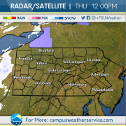
Who let the gust out? Yesterday and today have held their own in the whipping-winds competition as gusts have been recorded above 40 mph for many Pennsylvanians, namely those in the Philadelphia metro region. In the early morning hours, a cold front plunged from Canada, bringing along a cold air mass and snow squalls for many across the northern tier of the state to start the morning.

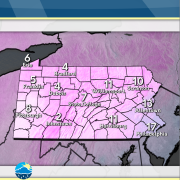
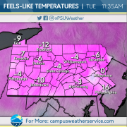
For the rest of today, temperatures remain seasonable, but gusts can become bone chilling — especially without proper clothing. To deter the cold during windy conditions, focus on covering as much skin as possible, as the contact between wind and your skin creates the uncomfortable feeling we all detest. Once your skin is covered, ensure that the thickness of your clothing is proper for the temperatures you’re expecting to experience.

Tomorrow’s conditions appear to be quite similar to today’s: snow will be falling for those in the northern tier and the Laurel Highlands to start the day, with seasonable temperatures, but windy conditions, making your commute outdoors uncomfortable. Be cognizant of road conditions during your morning commute if snow is falling and bundle up!

Past – Carlson

Present – Carlson

Future – Carlson

Support – Witte

Warmer and Windy?

Does it feel warm to you? After an extended period of below freezing temperatures, we are finally feeling temperatures that are more seasonable for this time of year. Currently, abundant sunshine and clear skies dominate the Commonwealth. Don’t forget to bundle up though, windy conditions will make it feel colder.

These gusty conditions will remain overnight, even bringing some wintry precipitation with them in the next couple days. Snow squalls are possible across the state, so remain weather aware! Stay especially alert on highways, as they can be dangerous in these conditions.

The upcoming week will bring chances for showers on Friday and the potential for freezing rain during the weekend. Prepare for Groundhog day! Maybe we will have an early Spring!

Beginning of a Weekend Warm-Up

Some bitter cold air took hold of the Commonwealth during the first half of the week. Wind speeds remained relatively breezy bringing wind chill values well below zero. These cold conditions were only amplified by a few clouds and the snow we received earlier in the week.

A slightly warm-up begins to make its way across the state. Still below freezing, we are heading back to near average temperatures for this time of year. The weekend brings the most promising return, nearing the freezing mark.

After the weekend and beginning the next work week, winds begin to pick up, keeping more cold air around. The middle part of the week may introduce some snow showers as a low pressure system approaches from the west. Keep those hats and gloves handy as the cold is going no where any time soon!

Condition to Remain BRRRisk Across the Commonwealth

An arctic blast took hold across Pennsylvania on Tuesday, with high temperatures peaking into the teens and low 20s. Dangerous cold was felt across the Commonwealth this morning, with the majority of the state seeing low temperatures below zero, with some areas of the Northern Plateau getting as low as -18 degrees. Extreme Cold Warnings and Cold Weather Advisories continued throughout the day on Wednesday, with cold weather alerts still posted for regions west of Interstate 99.

There is some good news to be found in the next 24 hours. A slight warm up will occur as we move into Thursday bringing temperatures up to the mid 20’s. With a high of 26 and a low of 12, Thursday’s temperature’s will be in stark contrast to the previous couple of days. This warming trend will continue as we move further into the week and the weekend.

The week ahead will bring much of the same, as the worst of the cold moves out by the end of the work week. Temperatures will remain 5 to 10 degrees below our average temperature of 34. The later half of the weekend into early next week will see temperatures warming up closer to average, peaking into the low to mid 30s. The best chance for snowfall will be in western Pennsylvania on Friday, as a weakening clipper brings occasional showers to the region.

Dangerous Cold Sweeps Commonwealth

A few inches of snow (along with relatively average temperatures) were brought to the Commonwealth during a winter low-pressure system on Saturday. Afterwards, temperatures plummeted Sunday and have continued through Monday with below zero temperatures overnight into Tuesday. Along with the cold temperatures, a high pressure system has been in the region keeping us dry. Wind has also been an issue, with wind speeds ranging from 5-15 mph, bringing hazardous wind chills to our region.

A cold front will move through the region tonight into tomorrow, continuing our chilly conditions with the lowest temperatures expected tonight into Wednesday morning, with the chance of lows reaching -10F . Following the cold front’s departure, high pressure will enter our region — keeping all of the state dry, but still cold. Temperatures will rebound as we head into Thursday with temperatures hovering in the mid-20s.

During the early-Wednesday morning hours , lake effect snow will begin to affect isolated portions of the I-90 corridor, lasting until the evening. For the rest of the state, high pressure will persist until Friday morning, with temperatures back into January’s averages. Friday morning brings a cold front, where high pressure quickly follows behind and lasts for the weekend.

Winter Storm to Bring Widespread Snow Sunday

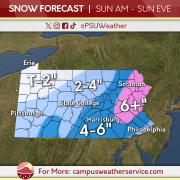
A winter storm is set to impact Pennsylvania on Sunday, with some areas expecting over a half foot of snow. Snow will start in the southwestern part of the Commonwealth during the morning, increasing in intensity throughout the early afternoon hours as the storm continues to move northeast. Intense snowfall rates are likely east of the Interstate 99 corridor during the mid afternoon hours, which will create travel impacts across the Philadelphia, Harrisburg, and Scranton/Wilkes-Barre metropolitan areas. Philadelphia could see a brief changeover to sleet between 3pm and 6pm, which will lower snowfall totals across areas of the southern Delaware River Valley. Northeastern Pennsylvania is expected to receive the most snowfall, with upwards of a half foot likely after this storm system is all set and done.

Snow is expected to wind down across the Commonwealth overnight Sunday into Monday morning, with Lake Effect snow possible in Northwest Pennsylvania throughout the afternoon hours on Monday. This snowfall will be here to stay as we head into the next work week, as an arctic air mass will move in behind this system. Temperatures across the state are expected to drop below zero as you wake up for your Tuesday and Wednesday commutes. Wind chill temperatures across western Pennsylvania could drop as low as 30 degrees below zero Wednesday morning.

Weather Blog 1/17/24

After a quick hitting snowfall throughout the day on Thursday, plenty of melting occurred on Friday, as temperatures peaked into the mid 30s to low 40s across the Commonwealth. Although many of these high temperatures were close to seasonal averages for this time of the year, conditions felt much more mild compared to the cold beginning of the week. Pleasant conditions were felt across much of the state, as early morning clouds subsided and gave way to more sunshine in the afternoon.

A pleasant day on Friday will be followed up by sloppy conditions on Saturday, as our next weather maker moves in, spreading a wintry mix across the Commonwealth. Snow will spread across the northwest region of the state from west to east during the morning hours. Although not much accumulation is expected, some spots may become slick. Precipitation will spread across the southwestern portion of the state, where up to a quarter of an inch of rain is expected with some snowflakes mixing into the higher elevations. The eastern half of the state can expect sprinkles of rain and some occasional flurries in the Poconos.

As the latter half of Martin Luther King Weekend arrives, we are watching a potential coastal snowmaker, with a widespread plowable snowfall likely across eastern Pennsylvania. Depending on the position of this system off the coast, some areas of central Pennsylvania may tap into the snowfall, with the western third of the state likely to remain dry. Following this snowmaker, an arctic air mass will drop temperatures into the single digits after the Monday holiday, with wind chill temperatures for the middle of next week dropping as low as 30 degrees below 0.

Hurricane Milton – October 9, 2024

NOAA GOES-EAST GEOCOLOR Satellite Imagery of Hurricane Milton

GEOCOLOR satellite imagery of Hurricane Milton from NOAA’s GOES-East Satellite.

As Hurricane Milton barrels towards Florida as a Category 5 storm, some residents are evacuating while others brace for the impact of yet another hurricane. Only two weeks after Hurricane Helene, resources are already stretched thin. With maximum sustained winds around 145 miles per hour and wind gusts upwards of 170 miles per hour (as of 11 am on 10/9), Hurricane Milton looks to slightly weaken as it approaches landfall.

Read more

Powerful Hurricane Idalia takes aim at Florida and the Southeastern US

Hurricane Idalia on GOES-East


Overview

Hurricane Idalia, pronounced (ee-DAL-ya), has become a strong category 2 hurricane in the eastern Gulf of Mexico, with its sights set on the big bend of Florida. As of the latest 8:00 PM EDT National Hurricane Center (NHC) advisory, the hurricane has sustained winds of 105 mph and is moving north at 16 mph. On satellite imagery, the storm appears to be very healthy with strong convection around its center. The system has yet to feature an eye but is expected to continue to restrengthen upon landfall Wednesday morning in Florida.

Related topic: Sex Drive Boosters for Men: Enhance Your Passion and Vitality

Severe Weather Threat – August 12th, 2023

The entire Commonwealth is under a severe weather risk on Saturday, August 12th, as the Storm Prediction Center (SPC) has placed certain areas under either a marginal or slight risk.

Read more