Stunningly High Temperatures Today

This weekend, rain from Hurricane Isaias made its way through Pennsylvania, causing precipitation to cover the entire commonwealth. Temperatures were above average statewide throughout the weekend.

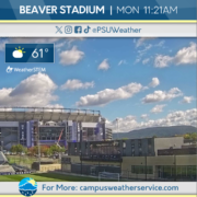
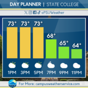
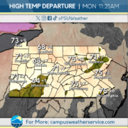
Temperatures continue to stay above average average today, reaching near record temperatures for much of the state. Skies are mostly sunny through a majority of the state today, with a few clouds present in the north of Pennsylvania.

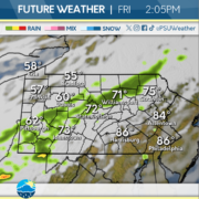
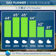
There is a chance for showers through most of the state tomorrow. causing lower temperatures for the remainder of the week. A low-pressure system will move through the state on Friday, bringing more precipitation through Pennsylvania.
Above Average Temperatures Ahead

We had a nice start to the weekend with temperatures reaching the high 60s across the majority of Pennsylvania. Cloud cover started to envelop the area by Saturday evening with the arrival of the remnants of Hurricane Isaias. Rain continued throughout the day on Sunday, with some areas seeing heavy rain (especially late Saturday Night).

Today is expected to remain mostly cloudy with a couple peeks of sunshine later in the afternoon. Temperatures will be above average, reaching the high 60s to low 70s across the Commonwealth. Humidity is also higher than average today, so it will be a little more uncomfortable outside than in previous days.

Tomorrow we will see gusty south winds, which will bring temperatures well above average. Temperatures are expected to rise as high as the low 80s across the entire Commonwealth. Skies are also expected to clear out, and it will be a beautiful sunny day tomorrow!

Pristine Conditions Expected Today

Dry weather has been prevalent throughout the Commonwealth this week. Over the past few days, temperatures have varied during the diurnal cycle. Winds were high throughout yesterday, but that will not be the case for today.

Pristine conditions are occurring throughout the day today, with seasonable temperatures and abundant sunshine. Temperatures overnight will drop into the lower 40s, but expect temperatures to rebound during the day on Saturday.

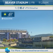
For your Whiteout game, expect dry conditions to persist, but clouds will move in throughout the day. This will lead to overcast skies during kickoff, but temperatures will be around 60 degrees for the game. Heading into Sunday, rain will prevail throughout the State along with gusty winds. This is associated with the remnants of Isaias, a hurricane that will impact the Gulf over the next 24-48 hours.

Tropical Tracker: How Will Isaias Impact Pennsylvania?

Last night, the first hurricane of the 2026 Atlantic Hurricane Season formed in the Gulf. Isaias is gaining strength as it heads towards a Saturday morning landfall nearby Pensacola, Florida. During that time period, the steering high pressure system that will define Isaias’s track across the US will be centered right over Pennsylvania. Friday and Saturday will be seasonable and sunny days, with high clouds streaming in Saturday night, making for another beautiful sunset just before the Whiteout Game.

The impacts of the storm come in on Sunday, with periods of moderate rainfall with a few heavier downpours possible. Winds will be gusty, similar to today across the Commonwealth. Power outages are unlikely as the storm will be post tropical by Sunday. Showers will linger into Monday, especially across Eastern Pennsylvania.

It has been quite the dry month across Pennsylvania, with most of the Commonwealth at least a half inch of rainfall below average for the month. This rainfall will be beneficial for any late growing season crops, but the increased winds may knock off a few more leaves right before peak foliage season across the Commonwealth.

It Sure Feels Like Fall

Following a bit of drizzle in the latter half of the weekend, Monday in PA was quite clear and crisp, with temperatures creeping just up into the 60s and only a few scattered clouds here and there. On top of that, dry air set in, and it looks like that will be the case for a bit of time going forward. This was about as good as fall weather can get.

Today is, for lack of a better term, the exact same. A bit extra warmth should aid in another pretty day, and even less moisture means skies should be entirely clear for most of the Commonwealth. Add in a light breeze, and one must really feel that fall has arrived.

If you enjoy the best of what autumn has to offer, you are in luck this week. This high pressure, seasonable and dry regime should hold at least through Sunday morning, with essentially no chance of precipitation until the beginning of the new work week. Fall foliage should also begin to become a factor as the week goes on: isolated pockets of moderate color exist right now at high elevations, but the rest of the Commonwealth should see color appear by the weekend. All that said, the remnants of a coastal low crossing the interior US would be our next chance at precipitation Monday and Tuesday, and this will have to be monitored as that time period draws closer.

Beautiful Fall-Like Conditions to Come

Temperatures were a bit below average across the Commonwealth this weekend. Saturday was sunny and dry, while Sunday saw increasing cloud cover and the occasional drizzle. Otherwise, overcast conditions were seen into the overnight.

Mostly sunny skies and seasonable temperatures are expected throughout the day today. Tonight will be mostly clear across the Commonwealth. Temperatures may dip near or below freezing in higher elevations, and patchy frost is possible.

Looking ahead to the middle of the week, temperatures should increase to a bit above average. Times of clouds and sun are expected to continue. Some patchy fog is possible in the morning.

Cold Front Brings Rain and Fall-like Conditions

Throughout the past few days, a ridge made its way towards the eastern half of the United States. This brought warm conditions and relatively high humidity across the state. A presence of a cold front will bring changes to our temperatures this weekend.

For today, expect a huge temperature contrast between eastern and western PA. Showers will be accompanied by this cold front as it moves east. Behind this front, expect fall-like conditions to return throughout the state.

Saturday looks to be beautiful across the Commonwealth with clear skies and seasonable conditions. Clouds will build up as we head into Saturday night and Sunday. Don’t expect the clouds to last as skies will clear out once again for the beginning of the work week. Heading into early next week, expect lows in the mid-30s throughout much of the state.

Above Average Temperatures Emerge

Effects from this past weekend’s Nor’easter are still very much here as clouds are still prominent throughout the State College area. Temperatures have remained around the average for this time of year but not for much longer.

As we head into today and throughout the later part of this week, temperatures will rise well above average. Today being slightly above average with a bigger jump as w ahead into tomorrow and Friday with temperatures being well into the 80s.

As we head into the weekend on the other hand, we will see these temps drop to the average for this time of year with a slight chance for some below average temps as a cold front passes through the state bringing the chance for some rain Friday and into Saturday. Partly cloudy conditions persist throughout the weekend into Monday and cooler weather is to follow.

Warming Weather for Pennsylvania

The nor’easter continued to impact the East Coast for the weekend, with a few lingering bands of rain moving through Pennsylvania. Temperatures remained seasonal on Monday, with cloudy skies dominating the Commonwealth.

Cloudy skies will continue throughout the day today, beginning to dissipate overnight. Temperatures will begin to rise, reaching higher than seasonable values for most of the state. There is no expected precipitation statewide.

Rising temperatures will persist into Friday, reaching their highest on Thursday for the state. Temperatures will begin to dip back down on Saturday after a cold front brings a line of showers through Pennsylvania on Friday.

Higher Temperatures on the Way

The weekend was dreary here in the Commonwealth, with clouds and rain showers moving in through late Saturday. Sunday saw multiple rounds of showers, associated with the outer edge of a Nor’easter impacting the eastern US. Temperatures were fairly seasonable, leading to a chilly, rainy, and fall-like weekend.

Today is expected to also feature seasonable temperatures with similarly cloudy skies, yet no precipitation is expected. Winds have also calmed down a bit following a blustery weekend.

Heading into the middle of the week, temperatures are expected to increase to well-above average for this time of year. Conditions are expected to be drier throughout the next several days as a ridge promotes pleasant weather across the Commonwealth. However, more precipitation seems possible this weekend.